
Hiking in Oku-Musashi 奥武蔵
Ask for a hiking map for Mt Futago
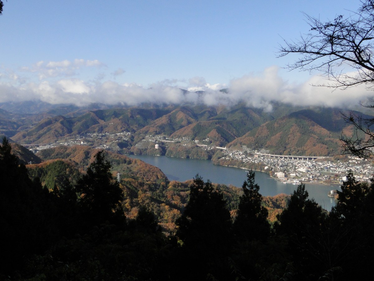
武川岳 takegawadake 二子山 futagoyama

I felt like it was time to try something different, something special to Japan; I wanted to do a hike next to the ocean. I found one such hike in my hiking book, but it seemed a bit short, so I combined it with a couple of nearby peaks. Although the elevation of these three mountains was relatively low, they seemed quite impressive when seen from the sea-side town of Yugawara, famous for its plum blossoms and hot springs. The area is also known for rock climbing, although today’s purpose was purely hiking.
HOW TO GET THERE: From Tokyo or Shinagawa station, catch the Tokaido line to Atami; Yugawara is the stop before. Depending on the type of train you catch, it takes between 60 and 90 minutes, direct or with changes. This is not a line I take often so it was a pleasant change with lots of views of the sea (sit on the left when heading out). From the station there are frequent buses to “Kaiya” which is the last stop. I was the sole person on the bus for the last portion of the trip, and on the first part of the hike.
THE ROUTE: The bus stops in front of a temple, but the hiking trail doesn’t go through it. There wasn’t anybody around to ask, but I found a sign for the hiking trail along the road that continues up the mountain to the left of the temple. The signposting was particularly poor on this hike, and some route-finding was needed (this was nearly ten years ago so things may have changed). I followed the road as it curved to the right and then back to the left again, with many minor roads branching off it. I eventually reached a sign pointing straight up a very steep slope; it must of had an inclination of 45 degrees; I cannot imagine driving up here with ice or snow, although I guess that it rarely happens in this area (it felt pretty balmy for December).

Japanese citrus fruit or mikan

Manazuru peninsula jutting into Sagami bay
Soon I was walking among the mikan trees with their bright orange fruit. I was getting pretty views of Yugawara town, Sagami bay and the surrounding mountains. I couldn’t see any more signs, but I decided to stick to the main road, a tough proposition since the other roads that branched off seemed to be the same width (wide enough for a small car). Instinct served me well, for shortly after entering a forest section, I found another wooden signpost for the summit. Unfortunately this sign was placed a few meters before another junction. I hesitated for a couple of minutes, and then continued in the most plausible direction which was straight ahead.

Looking South to Izu

Near the top of Mt Nango
Since I was going up the side of a steep mountain, taking the wrong way could have big consequences. Fortunately, as I reached the top of the ridge, I came upon a third and better sign marking the start of a proper hiking trail. The surrounding landscape had become quite fascinating, not because of its beauty, but because of the sense of abandonment. This area had enjoyed a boom a few decades ago, but was now in decline, and there were a lot of ruined buildings making it a little spooky.
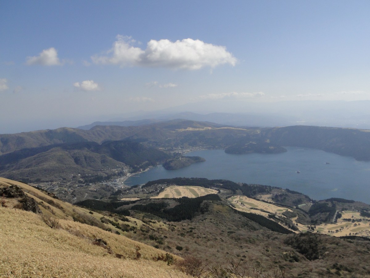
Now I was following a proper hiking path along the ridge. The views were hidden by the surrounding vegetation, lucky in a way, since it had become considerably windy. I was skirting a golf course, surrounded by an electric fence to keep trespassers (or hikers) out. I then reached a road, and after following it for a few minutes, I came to a hiking path on the left heading to the top of Mt Nango (南郷山 nangosan)about ten minutes away. There were some nice views of the coastline a few meters below the summit, better than from the summit itself. Here I met some other hikers, as it usually happens at the tops of mountains, and was easily able to get someone to take my photo.

Mountain scenery near the coast

Easy walking through the forest
After a short rest, I set out again for summit number two and the highest point of the hike. Here the signposting let me down again. At the first intersection, there were no signs for my mountain, only a sign going straight to a temple, and a one pointing for the road that running between the two mountains. I had to cross the road at one point, but according to my map, not before passing by a small lake. So I decided to continue straight ahead. This turned out to be wrong, and I was soon forced to retrace my steps. Back at the junction, I took the second path towards the road (now going right). This was a pretty trail, zigzagging down through a pine wood before reaching a flat wooded area, where I crossed what must have been the other path leading down from Mt Nango.

The path to Mt Maku

Getting close to the top of Mt Maku
Here I turned right and continued walking through some more delightful forest. I finally spotted the lake that I had been aiming for. It was a small and lonely lake hidden in the middle of the forest. Just beyond it was the road which I crossed in order to re-enter the woods on the other side. This part was really pleasant and made me want to bring other people here.
After a few minutes I reached the path heading for the summit. It took me another fifteen minutes of gentle climbing to reach Mt Maku (幕山 makuyama). From there I could see the ocean and the surrounding mountains. There weren’t any benches so I sat on the ground to have lunch. Since my view while sitting was obscured by bamboo grass, and the wind was terribly strong, probably due to the proximity of the sea, I decided not to linger.

Nice ocean views

Enjoying the soft autumn sunshine
Heading down, I mistakenly turned onto a path circling the summit. Once I realized this, I cut back through the woods and got back on the correct path. I was soon facing south and had some nice views of Sagami bay. I passed a group who had taken my photo on the summit, and left them behind me scratching their heads, since I had left ahead of them.
Eventually I got to the base of the mountain and got to see its famous rock climbing cliffs. There were a few people practising their skill in the good weather. It was interesting to note that they place mattresses underneath in case they fall. That’s Japanese safety for you. This is where the famous Yugawara plum trees are located (just bare branches at this time of the year).

The rocky base of Mt Maku

The rock climbing area
I was now following a paved road along the bottom of a valley. It was only 3pm, but the winter sun was already starting to dip below the surrounding ridges. I stopped to take photos of the beautiful colours of a maple tree and the shadows nearly overtook me. A little later I crossed a bridge, went straight another hundred meters, turned left up another smaller road, and ten minutes later reached a small hiking trail. The paved road continues around Mt Maku, and joins up with the path I went up on the other side.

Orange Maple tree

Short but nice river walk
Here darkness overtook me as the path twisted and turned through thick forest. There were a few ropes and chains, but nothing challenging. It was tough to climb up a mountain again, but it was too soon to head back. After about 30 minutes I reached a small shrine under a small waterfall. Above it, there was a paved path lined with stone lanterns switching back and forth; it felt rather sacred. At this time, there was nobody else around.

Walking along the valley before climbing again

The path to the shrine
I reached another road which I followed through a windy tunnel under the highest section of the ridge. On the other side, I emerged back into the sun. I followed the road one hundred meters to a lookout point and a bus stop. Behind the observation platform, I found the hiking trail again. It double backed towards the ridge and passed above the tunnel. This was an enjoyable section despite the strong wind, heading slightly downhill with occasional views of the adjacent ridges and the ocean.

In the sun again…

The Izu peninsula
A short while later I reached the final summit of the day, Mt Shiro (城山 shiroyama). It was the lowest of the three peaks, but it had by far the best view, with places to sit down and no vegetation in the way (and toilets as well!). At this late hour, I had the summit to myself. To the South was the Izu peninsula, to the North was the Shonan coastline, and beyond, the Landmark Tower in Yokohama, to the west was Oshima Island. The most amazing thing about this summit was that it was right at the edge of the sea. I think it’s the first time I have stood about 500 meters directly above the coastline.

The coveted ocean view

Looking back at Mt Maku
I had to pull myself away from this great view only fifteen minutes after arriving, since I really needed to get down before dark. I headed down at a fast pace, the path being relatively easy to walk. There another good view of Oshima island on the way. Very soon I reached a paved road. My map showed that there were a couple of shortcuts so that you didn’t to walk so much on the road. However I got tricked on the second one, it led basically nowhere, and I had to climb five minutes back to the road.
When I got to the real short cut, I didn’t dare to take it so I jogged the wide bend of the road. Soon I started seeing signs of civilisation again: telephone wires, houses and cars. There were again no signs and more roads than were indicated on the map, but following my instinct I ended back at the station by dusk. I celebrated by taking a hot bath at an onsen with outdoor bath just five minutes down the road, on the top floor of the hotel.

Final view of Ooshima
This was my second visit to Mt Sekiro (石老山 sekirouzan) and the first time taking other people; the photos will be a combination of both trips. I feel that this mountain is really exceptional: it’s close to Tokyo, easy to climb, it has great views (including Mt Fuji), there is a temple at the base, and finally there are few hikers since it’s not a famous mountain.

Mt Sekiro from Sagamiko Station
HOW TO GET THERE: Get on the Chuo line for Takao station, ride to the end of the line, and switch to the Chuo line again by simply crossing the platform. Get off at Sagamiko station, the next stop. The only tricky part here is catching a bus to the start of the hiking trail. Departures normally coincide with most train arrivals, but if the wait is too long, it’s possible to take a taxi since it is only ten minutes away.
THE ROUTE: From the bus stop, we crossed the road and headed up the road that lead away from it as a straight angle. There is a sign saying Sekirosan iriguchi (石老山入口 meaning entrance to Mt Sekiro) as well as a big sign showing the route. There are also toilets and a vending machine. After walking along the road for about twenty minutes we reached the start of the trail, behind a hospital. The weather wasn’t great, but it didn’t matter so much since the hike was mostly in the forest during autumn.
The first part of the hike climbed steadily through a forest of tall cedar trees next to a stream. Massive moss-covered boulders lay strewn on both sides of the path. Some had small signs with Japanese explanations on their legendary origins.

The road to the temple

Huge moss covered boulders
In less than half an hour, we reached Kenkyoji temple (顕鏡寺) perched on the lower reaches of the mountain; we took a photo break since it had some impressive autumn colours. Since there are no other mountains standing in the way, there was also a view west towards Tokyo, but clouds and smog meant that visibility was limited. Northwards, we could see Mt Takao, the closest mountain to Tokyo.
The trail continued behind the temple, winding back and forth, eventually a fork, unmarked on the map. We asked a small family on their way down who confirmed that the paths connected further up and that the right one was easier to walk. We took the right branch and were rewarded with some more nice westward vistas, as the path curved around the side of the mountain.

Autumn colours were in full swing

Orange and yellow fighting for dominance behind a stone lantern
Before we knew it, the paths joined up. From that point, the path climbed gently through the forest till a fantastic viewpoint of Lake Sagami. We couldn’t really see much of the view, since the weather was still cloudy. We continued up the mountain at a good pace and meeting few people. The path was a series of short steep climbs followed by flat or slightly downhill sections.
We reached the summit two hours after starting out. There were two or three tables where you can have a picnic while admiring the view of Mt Fuji. Unfortunately today the weather had steadily been getting worse, and there was no hope of seeing the majestic volcano today. We repaired to a table under a tree out of the cold wind that had suddenly started blowing, and prepared our ramen lunch.

View from the with Mt Omuro in the center (taken the previous year)

First glimpse of Sagami lake on the way down
Even though it was the first of December, the temperature had been warmer than expected. However it suddenly turned freezing and the clouds got greyer. I noticed some white specks on the table; amazingly, it had just started snowing! it wasn’t even the beautiful snowflake type of snow; it was the hard granular kind, that was more like sleet, forcing us to gulp down our lunch, and leave as quickly as possible. By that time, my fingers were feeling pretty numb from the cold.
I had originally planned a loop hike but decided on the spot, that we should head down the same way; it would be safer to down a familiar way in a freak snowstorm. However, as soon as we got a few meters from the summit, the snow stopped falling and it felt noticeably warmer. Ten minutes later we had blue skies above our head and the sun was shining. The storm was over just as quickly as it had started. The path looked quite different going down especially now that the weather was so good. The view of lake Sagami was completely different and we could see the mountain ranges beyond.

Sunny woods

View towards Tokyo
At the junction, we took the other path so as to complete the loop. Just below, there is a good view of Mt Sekiro, as well as the mountains to the west. The path passes through some more huge boulders, but it wasn’t particularly difficult. We got down ninety minutes, and after a twenty minute wait, we were able to hop onto a bus back to the station. In good weather, it’s possible to continue beyond the summit and make a loop back to the start of the hike.
CONCLUSION: Great hike for the late autumn / early winter period, because of its short length and relatively low altitude. It can be combined with some neighbouring mountains if you are a fast hiker.
As of October 2020, the trail around Kenkyoji Temple (顕鏡寺) is still closed due to trail damage due to last year’s Typhoon 19 / Hagibis – it’s not possible to reach the summit of Mt Sekiro via this route. No reopening date has been set yet. Please check the Sagamiko Tourist Association website for future updates.

The Takao range seen from the temple
Even though Mt Myogi 1104m (妙義山 myougisan) is a two hundred famous mountain , I didn’t actually climb to the top (I thought about it though). The reason being that despite its relatively low altitude, this is a dangerous and difficult mountain to climb. I used to think that you could walk up every mountain in Japan, chains and ladders being placed in the dangerous parts, and also Mt Tsurugi (in the Northern Alps) was the most difficult mountain to climb in Japan. However, this title probably belongs to Mt Myogi. All the trails to the summit are marked with dotted lines, meaning “experts only” with multiple danger signs and worrying comments added into the mix (“50m chimney – a lot of people have died here”).
I ended up doing the scenic and safe tour along of the base of the mountain – not only were the views fantastic, but it also included some exciting parts that weren’t dangerous – as long as you’re sure-footed. Finally, Mt Myogi is one of the 3 sacred mountains of Gunma prefecture (the other two being Mt Akagi and Mt Haruna). There are shrines at the start, Myogi Jinja, and at the end of the hike, Nakanotake Jinja.
HOW TO GET THERE: I had been putting off going to Mt Myogi for years, since I had always thought it was hard to get to. I first saw this mountain while staying overnight with friends in Tomioka; it seemed an exciting climb because of its rugged peaks, but at the same time it seemed really remote. So I was surprised when it took around 2 hours from Ikebukuro station to get to the closest station, Matsuida, on the Shin-Etsu line, a couple of stop before Yokokawa (transfer in Takasaki). The view from the station exit was stunning – there were no surrounding mountains and Mt Myougi seemed quite close. I could also see a snow covered Mt Asama just behind it. Unfortunately, I didn’t take a photo, thinking I would get a better view on the hike, but never did.
There is no bus from the station to the start of the hiking trail. You could walk along the road or take a taxi to Myougi shrine (one hour / 4 km). On the other hand, a taxi takes about 10 minutes and costs about 1400 yen. I’m not really sure about the exact price, since I was able to share the taxi with 3 other hikers, and we split the fare – I paid only 400 yen. One thing I can say for sure is that demand exceeds supply; there were more hikers than available taxis, and I had to wait for a taxi to complete the round-trip before I could get a ride. I still managed to be at the start of the trail just before 10 am – two hours and a half after leaving Ikebukuro station.
There is a bus running from Joshu-tomioka station on the Joshin Dentetsu line, south of Mt Myogi, but not only does it take longer to reach that station by train, the bus also takes forty minutes, basically adding one hour to the travel time, so I wouldn’t recommend going this way.
THE ROUTE: From the taxi drop off point, I headed up the street on the right to the Myogi shrine and to the start of the hiking trail beyond it. In some respects the base of this mountain is similar to Mt Tsukuba – many people visit it to see the shrine and pray. My original plan was to walk the Chukan path (中間道 meaning the middle path) along the base of the mountain. However I wanted to add on a loop that would take me close to the easternmost summit and where I could get some good views (according to my map). Since I had planned to return by taxi, for once I had no concerns about having to hurry to catch a bus at the end of the hike, except maybe getting off the mountain trail before it gets pitch black (after 5pm in this season).

Sugi and Momiji (Cedar tree and Maple tree)

Mt Haruna, one of Gunma’s sacred mountains
Once I was past the Shrine grounds, I left the bulk of the sightseers behind me. I soon saw beautiful momiji (maple leaf tree) showing off beautiful autumn colours. Although the “Koyo” season had already ended on the higher parts of the mountain, it was now in full swing around the base. The path soon started to climb. I propelled myself up the steeper inclines with the aid of the chains lining the path. At this stage, it wasn’t really dangerous, one could easily walk up, but using the chains made it easier on the legs (as long as one has gloves).

Mt Hakuun, so close yet inaccessible

The Southern part of the Myogi range
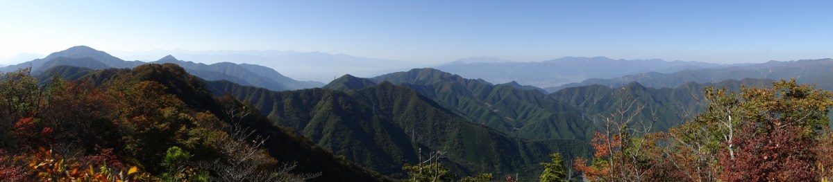
At one point I reached a huge boulder with chains that supposedly had a viewpoint on top. Thanks to my long legs and arms, I clambered to the top in a matter of seconds. I was standing next to a big-sized “big” Chinese character. The view was great, since it was a blue sky day. In front of me stretched the Kanto plain. To the south was a mass of peaks forming the Northern part of the Chichibu mountains. To the north, I could clearly see the massive bulks of Mt Haruna and Mt Akagi. In the far distance I could make out the snow covered peaks of Mt Hotaka, Mt Tanigawa and various other peaks of the Joshinetsu-Kogen National Park. Winter had definitely arrived to that part of Japan. And of course, just behind me, was one of the steep and rocky peaks of Mt Myogi, Mt Hakuun.

Autumn Colours galore

Believe it or not, there is a ridge route following the top
I had to wait a little to clamber down again since the the rock was currently being tackled by a rather cautious hiker. Finally, I was able to get back onto the hiking trail. Very soon I reached a junction where one route continued straight to the summit, and the other, heading left, went down again, and connected with the Chuukan path. I decided to check out the summit trail before taking it.
Within minutes I was scrambling over rocks again and holding on to chains, but nothing I hadn’t done a hundred times before on other mountains. Finally a reached some steps leading to a ladder, at the top of which was a cave. I ventured inside and discovered a small shrine. On the other hand, there was no more path, just a wall of vertical rock. I retraced my steps, and managed to pick up the trail again to the right of the steps, beyond a towering cedar tree. I wasn’t surprised I had missed it since it wasn’t a path but a steep rocky incline with a chains and some footholds. Now I’ve done a few of these before but none quite as long or as steep. I pulled myself up halfway, but I didn’t feel all that safe – a fall would result in more than a few bruises – so I decided end my little reconnaissance there, and get on with the main hike.

The craggy peaks of Mt Myogi
Past the trail junction, there was another passage with chains, as well as some sunny viewpoints. I stopped at one of them to have lunch. Eventually I joined up with the Chuukan path. It was a very pleasant up and down path (more up than down). There were some truly fantastic autumn colours along the way, and I couldn’t believe how few people there were. Later on, I read on the internet that thousands of people were on Mount Takao the same day.
After a while I reached a series of steps taking me very close to the top of one of Mt Myogi’s peaks. I didn’t expect the trail to go that high, perhaps 1000m, but it was hard to tell from the map. At this point the skies had clouded over a little, but the views were still above average. I was now walking along the base of a cliff. At times the path was carved inside the cliff, like a cave, forcing to walk bent over. This was undoubtedly one of the highlights of the hike!

The long staircase

The low overhang
Later on, I arrived at a viewpoint, reached by a series of rocky up and downs fitted with chains. There were more people here since this spot is closer to the other end of the Myogi range, where there is a shrine and a car park. While waiting for my turn to go down the chains, I took lots of photos of the mountains stretching away to the south. There was one especially that caught my eye – Mt Arafune. It had a very long flat top like a table, quite an intriguing sight.

Lots of hiking possibilities

On the right, the flat top of Mt Arafune
At the end of the path, I was also able to enjoy a great view of Mt Myogi to the North. The sun had come out again, and the whole range was bathed in a late afternoon sunlight, perfect for taking pictures. Once I was satisfied, I headed back to the main path, went down some more, under a rocky bridge, through a picnic spot and then up to another viewpoint, where I could check out the rocky crags I had clambered over just a few minutes before.

The northern part of the Myougi range

Not an easy path
The sun was slowly, but surely, heading for the horizon. I continued my descent, and quickly reached Nakanotake shrine. It was nice to start and end the hike at a shrine. I passed through quickly and got back on the road for the last part of the hike. It took me another hour to get back to my morning starting point. Along the road there were excellent views of some of Mt Myogi and surrounding mountains. The blue skies had returned, so even though the sun had already set it was still light.

Typical Myougi landscape

Mt Kondou the other main Myogi peak
Soon I entered a hiking path going down through a forest, a shortcut since the road make a big loop Eastwards. Very soon I was back on the road. I finally arrived at the turn-off for Momiji no Yu, a very conveniently located hot spring. After a nice hot bath, I called for a taxi; the return leg was more expensive, about 2300 yen, but since it had me almost nothing on the way there, I didn’t mind at all.
CONCLUSION: A medium-level hike with some thrills and great views, suitable for non-experienced hikers, and especially beautiful in the autumn. If it weren’t for the taxi ride there and back, and some road-walking, it would be the perfect hike!

Nearly full moon tonight

Great views on the walk back as well

Mt Kenashi is a famous mountain but not part of the original one hundred. It is part of the famous two hundred mountains, which isn’t too shabby considering that there are thousands of mountains in Japan. It sits opposite Mt Fuji and thus has some excellent viewpoints of Japan’s most famous volcano. Consequently, there are quite a few people climbing this mountain.
HOW TO GET THERE: The biggest drawback is that this mountain is tough to get to from Tokyo. You will need to shell out 5000 yen to take the Shinkansen from Tokyo station to Shinfuji station in Shizuoka (about an hour), and then put down another 1300 yen for the bus to the Asagiri Green Park entrance (also about an hour). To take your mind of all this spent money, there are great views of Mt Fuji along the way.
Fortunately the way back is slightly cheaper. At the end of the hike you can catch the same bus taken in the morning and get off in Kawaguchiko. From there, you have a choice between a local train or the limited express back to Shinjuku. The latter is more expensive and only runs a few times a day. Alternatively, you can take a bus to Shinjuku station for less than 2000 yen. However if you are going back on a weekend, beware of traffic jams. You could also take this way to go there but you would end up at the start of the hike half an hour later, and to trains heading out to the Mt Fuji can be packed (less so so on the way back).
This map was developed for Japanwilds with the Hokkaido Cartographer
Find Japan Hiking Maps on Japanwilds
THE ROUTE: Once again I was the only person to get off the bus; it seems that most people come here by car. I had to walk along a flat road for about half an hour to reach the base of the mountain and the start of the hiking trail. The view of Mt Kenashi towering above me was impressive; I wondered if I really was going to be able to manage this long and steep 1000+ meter climb. On the way I passed a wide and grassy camp site on my right with some excellent views of Mt Fuji. I definitely want to camp here some time in the future.
At the end of the long asphalt road I turned left following the signs for Mt Kenashi. Eventually I entered the forest, passed numerous parked cars, and started climbing along a rock path. There were two main paths up Mt Kenashi. I chose the shorter one so that I would have enough time to take the long ridge route down. The path was divided into 10 stations each marked with a sign, similar to the Mt Fuji stations. I passed quite a few people going up and down the mountain. The weather was sunny and not too cold for a November day, although judging from the absence of leaves higher up, it seemed that autumn was already finished on this mountain.

Mt Kenashi with the camp site at its base
As expected the climb was seemingly endless. Similar to when I was climbing Mt Takanosuya in the mist, the top ridge always seemed to be out of reach, always just beyond my level of vision. Every time the path became level, and I thought I was finally there, it would surprise me by rising steeply again. I was slowly getting higher than the rest of the ridgeline, and it felt like I was ascending some kind of spire.
At last I reached a small rocky outcrop, marked as a viewpoint of Mt Fuji. I decided to have an early lunch there, not because I was especially hungry, but because the view was fabulous; there was a comfortable unoccupied sitting spot, and there was no guarantee of something similar at the summit. However I only got past my first sandwich when I was forced to flee because of a group of hikers that talked loudly behind me while taking photos of the view.

Pine tree forest at the base of Mt Kenashi
From this point I reached the top ridge quite quickly. I overtook a lady hiker for the second time, who couldn’t figure it out how that was possible (she hadn’t seen me taking my lunch break on the rocky outcrop earlier on). From there, on it was an easy stroll to the summit of Mt Kenashi (毛無山 kenashiyama – means hairless mountain). Interestingly, just by stepping onto the ridge, the temperature dropped to near freezing. At nearly 2000m, winter had arrived.
As expected, there were plenty of people at the summit. I still managed to find a decent spot to sit down and finish my lunch. Unfortunately, the view of Mt Fuji wasn’t as good from here. However, before I could tuck in, a friendly hiker told me (in good English) that if I continued ten more minutes along the ridge line, I would reach a much better spot for lunch with a 360 view, including Mt Fuji and the Southern Alps. That seemed like a very attractive proposition, so after having him take the obligatory photo of me and the summit marker, I set off for this perfect lunch spot.

The first view of Mt Fuji before the summit
Sadly, I never found it, and one hour later I reached the next summit, Mt Ama (雨ヶ岳 amagadake), the last viewpoint before going down the mountain, and last chance for a (late) lunch. I was lucky I had eaten something before reaching the top, since I wasn’t able to find any good sitting spots with a view along the ridge. Even when I had a 360 degree view, the bamboo grass on either side was just too high to sit down comfortably. I guess the other hiker had walked the ridge in other seasons when the grass hadn’t been so high. The ridge was a mix of cold and shady forested sections, and warm and sunny grassy sections. The views of Mt Fuji were the best I had ever seen since the sun was behind me; I could make out all the details of the snowy rocky summit area. There were also far less people walking the ridge, since most people, having come by car, had to go up and down Mt Kenashi the same way.
I found a rectangular block of stone perfect for sitting. moved it into the sun and sat down to enjoy the rest of my lunch while examining Mt Fuji. However, I couldn’t stay too long however since I had a bus to catch. Soon I could see lake Motosuko on my left but too many branches in the way meant that I couldn’t get a good picture. Oddly enough I had the same kind of experience going down as when going up. Three times I thought I had reached the lowest point between 2 peaks only to discover that the path dipped further down.

Picture perfect view of Mt Fuji along the ridge
Finally I reached the flat part between two peaks and at another viewpoint of Mt Fuji, I saw the escape path for the bus stop leading down to the right. Here I met a male hiker on his way up. He told me that he was going to camp at the top of the mountain so that he could see the sun rising above the summit crater of Mt Fuji the next day, also called Diamond Fuji. It’s something I have never been able to see, but at the same time I don’t think I want to put in some much effort.
After a short while I reached a junction for the Tokai Nature trail. I had to jog along the last flat portion of the way, and I finally reached the bus stop with less than five minutes to spare. The bus back was empty at first but filled up quickly at the next stop. Despite that it was an enjoyable ride since you could see Mt Fuji from time to time.
CONCLUSION: A difficult but rewarding hike with fantastic views up a famous mountain that will see the crowds melt away during the second part.

View to the South
This hike follows the Western half of the caldera around Onuma lake 大沼 on Mt Akagi, passing several minor peaks opposite the highest point of this dormant volcano, Mt Kurobi 1828m (you can include it to make a longer hike). Mt Akagi is known as a hyakumeizan, and many people visit just to go up and down Mt Kurobi. However, like Mt Haruna closeby, there are many smaller mountains and hiking trails that are worth exploring (like Mt Suzu).
HOW TO GET THERE: Take the train to Maebashi (I took the shinkansen to save time), then a bus to the Akagi visitor centre. Some guy was handing out brochures about Mt Akagi to every person on the bus and, after we departed, was giving explanations about Mt Akagi through a microphone nearly the whole way. Slightly annoying but I still managed to doze off eventually (this doesn’t happen every time though).
The bus was pretty full and everybody got off one stop before the end. This was the closest stop to the lake. However the start of the Mt Akagi hiking trail is between that stop and the visitor stop (the terminus), so it doesn’t really matter where you alight.
THE ROUTE: It took about 30 minutes along the road from the visitor center to the Akagi campsite on the other side of the lake. The start of the hike was tricky to find – according to the map, the trail started before the camp site when actually it started from within, just behind the toilets. I had actually given up after walking up and down the road looking for any trace of a trail, and finally spotted it when I decided to go to the bathroom.
It was a nice signposted trail that quickly headed past a few holiday houses and then up the mountain. The lake is already at 1350m so there really wasn’t much climbing needed to get to the caldera ridge (around 1500m). The main trail went left, but I first walked about 50 meters to the right and got to a small rise called Mt Ashigara 1474m (足柄山) according to the map (there was no summit marker).

View from the summit of Mt Debari
I retraced my steps, circling the caldera counter-clockwise, and arrived at Mt Jingasa (陣笠山 jingasayama) with a summit marker and views of Mt Akagi. A little further on I reached the summit of Mt Yakushi (薬師山 yakushidake). There was really no one on the ridge which was amazing considering the amount of people on Mt Akagi. Afterwards, the path suddenly changed direction, heading over the ridge and down the other side. Mt Akagi has a jumble of peaks, and at times it can be a little disorientating. However very soon the path turned again into the right direction, and before I knew it I was on the top of Mt Debari (出張山 debariyama).
Mt Debari was the best summit by far with lots of places to sit, and some very nice views of Mt Kurobi and Lake Ono. After spending some time there I moved on and slowly started going down the caldera back to lake level. There were several paths going down to the left signposted to some nature house, but the correct path is straight ahead until a T junction. At this stage, I turned right towards the lake (the path heading down to the right is the Kanto Fureai no michi – see Mt Suzu above).

Mt Kurobi and Ono Lake
Eventually I reached the lake and walked along the road for about 20 minutes. With the sun in my back, it was a good place to take photos of Lake Ono. After passing some houses, I saw a sign for an observation platform going up a steep field on the right. After the steep climb the path became level, and after going through some forest, it took me to the treeless summit of Mt Miharashi (見晴山). There was an observation platform just a little down the path on the other side but the view was similar to the one observed earlier. The path continued a short way to the road from Maebashi.

View from the lake shore
On the other side of the road was the start of the trail for Mt Jizoh (1673m). I hiked it on a separate trip to Mt Akagi, but it makes a good extension if one has enough energy and time left. Today it was already late, so instead I followed a nice wide and mostly flat hiking path going around its base before connecting with the main road again. From there it was straight back to the bus stop. A few meters before the Akagi visitor centre 赤城公園ビジターセンター there was a nice wooden cottage that doubles as a restaurant. I popped in to get a snack, and was warmly welcomed. I was invited to sit in front of the fire and offered hot tea. A nice place to wait if there is some time before the bus leaves.
CONCLUSION: An easy but fun hike up and down some relatively obscure peaks with nice lake views, suitable for anyone who wants to get away from the crowds. The main drawback is that unless you climb Mt Akagi as well (or have your own car) you will have to walk along the road to reach the start of the hike.

View from the lowest peak of today’s hike
This isn’t a very famous mountain, but many people climb it since it’s one of the ways up Mt Kumotori, a hyakumeizan, as well as the highest summit in the Tokyo prefecture. It’s also inside the Chichibu-Tama-Kai National Park. I left Tokyo (the city) under the sun, but arrived under clouds and drizzle – how the weather can change fast!
HOW TO GET THERE: The best way is to hop on the early morning direct train to Okutama from Shinjuku station, otherwise you will need to change trains at least twice. If possible, sit in the front carriage, since this will put you close to the station exit; then make sure be at the front of the line for the bus, since this will guarantee you a seat. The bus for Nippara, also the stop for this hike, departs right in front of the train station.
THE ROUTE: After getting off the bus, I quickly continued walking along the road through the village. I knew the way since I had been here earlier this year to visit the Nippara caves. Also I was on a tight schedule and I didn’t have time to dawdle. Since the mountains were shrouded in mist, for once I didn’t lose any time taking photos. I arrived at a sign pointing to a footpath going down to the left, leading into the forest, over the river at the bottom of the valley and up the other side. It was pretty, but also slightly spooky, since there was no one else.
The path led me to a river bed through a ravine – it was remarkably beautiful (but difficult to take in photo). The approaching sound of bells told me that some other hikers were right behind me, but I lost them quickly on a steep slope. It took me away from the riverbed, and to the start of a rocky outcrop jutting above the ravine I had just climbed. Another group of hikers returning from the top of this outcrop told me it took 15 minutes to reach.
Despite my tight schedule I decided to attempt it since I was making good time. The rocky outcrop was somewhat slippery because of the recent rain, and turned into a bit of a scramble at the end. However it was worth it – even though the surrounding peaks were hidden in the clouds, I could see down the valley and the Nippara village below. Trees were showing their autumn colours here and there. It was hard to believe I was still in Tokyo prefecture.

View from the rocky outcrop – yes this is Tokyo prefecture.
Fifteen minutes later I was back on the main trail, and set off at a fast pace to make up for the lost time. Soon I was surrounded by mist. This made the climb doubly hard because it was impossible to see the summit – every time I thought I was about to arrive, the mist gave way to more forest and more climbing. Everything around me was silent and it felt a bit gloomy.
Finally I reached the top of Mt Takanosu (鷹ノ巣山 takanosuyama). There were a lot of people, but still plenty of space to sit down and have lunch. As expected there was no view to reward my efforts – just a lot of uniform whiteness. I headed down at once after lunch. There was really no point in hanging around, and I wanted to get back on schedule so that I would have time to take a hot bath at the end, and catch the direct train back to Shinjuku.
I thought that the way down was much nicer than the way up – a nice wide grassy ridge similar to a fire barrier. The mist went from spooky to mysterious. Suddenly I came to a point where the ridge turned right and went steeply downhill. The hiking trail seemed to be heading the same way. I was afraid of going down the mountain too soon, so I started to consul my map. Another hiker who had also been checking his map at the same place, told me this must be the right way. He was quite convincing so I started to follow him, anxious not to lose any more time. The path levelled and all seemed well; it started climbing again, became faint and then disappeared. We both stopped to look for it through the mist. Eventually I found it twenty meters to our right. We were on a minor summit and the main trail had gone round it. I said goodbye to the other hiker, and continued ahead at at a fast pace. Funny things like this happen all the time.
Soon I came close to another minor summit, Mt Mutsuishi 1478m (六ツ石山 mutsuishiyama). The name means six rock mountain. It was only 5 minutes to the top so I went up. The top was grassy with some trees but looking back I could see Mt Takanosu. Since the elevation of Okutama station is only 350m, I knew I still had a long way down, and I quickly set off again. Soon the weather cleared up a little, allowing some sun through. I slipped on some rocks on a steep slope, somehow spinning around 180 degrees and landing with my chest on a rock. It knocked the wind out of me, but otherwise no damage done. Lower down, I had to navigate a slippery muddy path through thick forest. At one point I slipped again. After that, I decided to leave the path and walk through the forest alongside it. This is one reason not to go hiking after a period of rain.
Eventually I reached gentler slopes, an easier to walk path and finally a paved road. I was probably just above the old Okutama road which I had walked this year in May. At the entrance of the hiking path, there was a sign that a bear had been spotted at this location a few weeks ago. For one’s state of mind, I find it better to know this after the hike, rather than before. After another 30 minutes I was back inside Okutama town. From past experience, I called the hot spring Moegi no yu, but they told me it was very crowded at the moment and I would have to wait to get inside. I decided to skip my hot bath so that I could catch the last direct train for Shinjuku. As a consolation, I treated myself to some local sake on the ride back.
CONCLUSION: A surprisingly good hike with some pleasant ridge walking ending at the station. Definitely worth another shot in better weather. The official name for the hike from the summit down to Okutama is the Ishione Ridge Walk (石尾根縦走路 ishione jusoro).

Beware of bears
The main reason to climb Mt Shakushi, a Yamanashi 100 famous mountain, is to enjoy the fantastic view of Mt Fuji from the summit; there are no mountains in-between, just fields and forest surrounding Oshino village below. The hike is mostly along a ridgeline, with several smaller peaks along the way. Although I was hiking in the middle of November, there were few autumn colours.
HOW TO GET THERE: Take the limited express for Kawaguchiko station, and get off one stop before the end at Mt Fuji / Fujisan station (used to be Fujiyoshida station till 2010). This convenient but pricey train will get you to Fujiyama in time for the bus for Oshino village. It’s also possible to take a combination of local trains, but the connection won’t be as good. I was the only person on the bus – I guess everyone else had gone to see the autumn colours around Kawaguchiko lake.
This map was developed for Japanwilds with the Hokkaido Cartographer
Find more Japan hiking maps on Avenza

THE ROUTE: From the bus stop, I headed along a road with Mt Fuji to my back. After crossing a couple of small streams I started seeing signs for the entrance to the hiking trail. Very soon I walking along a dirt road surrounded by beautiful forest; it felt very different from hiking trails closer to Tokyo, especially since there was no-one else around. Eventually I overtook a family of five who had come by car.

The sun was perfectly aligned above Mt Fuji
After climbing steadily for a while, I reached a pass where I turned left up the main ridge. I soon reached a rocky roped section, with a nice view of Mt Fuji to the side. After the obligatory snapshots, I continued towards the summit. After a while, I arrived at a junction, from where it was a short round-trip to another summit called Mt Shishidome 1632m 鹿留山 (shishidome-yama). Since there was no view, I decided to skip it and continue on my way. The path was now slightly downhill.

A good day for paragliding
Suddenly I came upon the perfect lunch spot – a lonely rock with a stunning view of Mt Fuji. Even though I was a short way from the summit, I decided to stop for lunch; the final part was mostly flat, and peaks can be surprisingly crowded even when there seems to be no one else on the mountain. Occasionally other hikers would stopped behind me to admire the view, but overall it was a very enjoyable lunch. Not only could I see Mt Fuji in front of me, but also the South Alps (some of the highest peaks were already covered in snow) and lake Yamanaka. Eventually I managed to pull myself away from the view and reach the summit.

Mt Mitsutoge to the West
The top of Mt Shyakushi (杓子山 shakushi-yama) has a couple of benches, and interestingly enough, a bell to scare away bears. I was so busy taking photos of Mt Fuji, I completely forgot to ring it! I was glad I had already taken my lunch break – the sun was moving behind Mt Fuji, and the side facing me was slowly becoming a dark outline. It looked like the sun would set exactly behind the cone, a phenomenon called Diamond Fuji. Unfortunately, there was no way I could stay till sunset, even though it was nice and warm in the autumn sun.

View of Mt Fuji while descending
I hurried down the trail, quickly reentering the forest and losing the Mt Fuji views. I soon passed a jump-off spot for paragliders, just above Ozasu Pass (大権首峠). On the right was the forest road leading to Fudoyu, however I continued straight ahead. After some up and down, including a couple of rocky sections, I arrived at the top of Mt Takasazu (高座山 1304m). A short, steep descent brought me to the top of a wide Japanese Pampas (“susuki”) grass field. Walking along the top edge, I had many dramatic views of the outline of Mt Fuji, against the slowly sinking sun. At 4pm, just as it was getting dark, I was finally back in Oshino village where I caught a bus for Fujisan station.

This 100 famous mountain of Yamanashi would deserve a place among the 200 or 300 famous mountains of Japan. It offers a challenging climb and a wide view from the top, including Mt Fuji and the South Alps. The trail is also easily accessible on foot from Sasago station on the Chuo line. Funnily enough, it’s not called a “yama” (mountain), but a “maru” (circle).
HOW TO GET THERE: Take the Chuo line from Shinjuku station and get off at Sasago station a couple of stops past Otsuki station. Don’t do like me: fall asleep and miss your stop. I was lucky to be able to get off two stations later, and catch a train back within ten minutes – there are only about 2 trains an hour out there.
THE ROUTE: From Sasago station’s sole exit, walk up the road on the right. Within 50 meters you will reach a T-Junction. This was probably the most confusing part of the hike, since the hiking sign clearly points to the left, whereas my map indicated a right turn. According to the map the left trail was a hard to follow route to another summit on the same ridge. Since it was published 3 years ago, things may have changed.
I decided to go right anyway, and after walking along a dirt road for about 15 minutes, I was relieved to spot a sign for the trail entrance, pointing to a dirt trail going up the mountain on the left. I set off along it with renewed confidence, only to reach an unmarked branching barely ten meters further. The left branch followed the bottom of the valley, and the right one went literally straight up the mountain side.

The beautiful ridge line path
Having already lost a significant amount of time by missing my station, and locating the trail entrance, I followed my gut instinct and went right. I guessed that the paths would probably join up later, as it often happens when you encounter an unmarked branching. They never did, and for the time being it was a mystery.
I quickly discovered that my chosen path was extremely steep – so steep that a couple of times I had to kick in the dirt with the tip of my hiking shoes to get a grip. The path was also very faint; I was starting to wonder whether it was the right choice after all when suddenly I saw a pink ribbon attached to a low branch, the unofficial trail marker throughout the area. The climb to the first shelf was intense, and left me gasping my breath at an electric pylon. After that it was easier going. The surrounding forest was beautiful and felt quite wild.

Some autumn colours
There was another confusing part about an hour after I started climbing, when the path disappeared into some dense vegetation, some sort of grass that had grown out of control. There wasn’t a clear path leading around it, so in the end I picked up a stick and literally beat a path through it myself. I finally emerged onto a road on the other side, as predicted by my map, and thus confirming that I was on the right path.
After the road, there was another very steep dirt path requiring more kicking. Eventually big rocks and boulders started appearing on either side of the path, a sure sign I was approaching the summit ridge. At last, I reached a minor summit 1377 meters high, but there wasn’t much of a view, so I soon continued along the ridge line. After a while I got to see some beautiful autumn colours, looking amazing with the blue sky in the background.

More autumn colours
Finally I started getting some glimpses of Mt Fuji. After confirming with a descending hiker that the summit had a clear view of Mt Fuji, I hurried along till I reached the summit of Honja-ga-maru 本社ヶ丸, and a stunning view. To the south was glorious Mt Fuji, so close I felt could touch it; in front and to the left was Mt Mitsutoge, a 200-famous mountain; to the West were the South Alps; to the North were Yatsugatake and the mountains of the Chichibu-Tama-Kai national park; the view to the East was hidden by trees. I found a good sitting spot on a rock with a view of Mt Fuji, and had by lunch.
After lingering as long as I dared, I started downhill, continuing along the ridge. There were several more excellent viewpoints on the way. The surrounding rocky scenery felt very wild. On the way, I scared away a family of partridges. At one point, there was a path leading down to Sasago station to the right. I ignored it since I intended to follow the ridge lime for some more time before heading down.

Mt Fuji in the autumn
Just after that there was another tricky part – the path switches back and goes down the opposite side of the mountain. This is the path to Mt Mitsutoge. Shortly after you go under the trees, there is small path leading right and following the ridge again. The sign has fallen down so it is easy to miss. At the fork for Mt Haccho (八丁山 haccho-yama), I turned right to get off the mountain. The round-trip to the top of this mountain takes barely 15 minutes, but I had to drop it since I had lingered too long at the summit, and was in a hurry to get down before it got dark.

View south from the top
A little further there was yet another tricky part. A little before Onna-zaka Pass (女坂峠 onnazaka-toge), there was a path to the right for Sasago station that wasn’t on the map. The route through 女坂峠 was longer and involved an up and down, whilst this new route was more direct. Actually, we were 3 hikers hesitating at this sign. In the end, as evening was arriving quickly, we all chose caution over adventure, and took the fastest route back to the station. Unfortunately, it was also probably the least beautiful option as it descended quickly through secondary forest. As a consolation, it did offer some nice views of Honja-ga-maru and the surrounding peaks.

Honjagamaru from near the end of the hike
Finally after going back and forth through some newly planted pines trees, the path joined up with the official map path. This was the path to the station I had ignored earlier. I was glad I had taken the ridge line path on the way up, since it was truly beautiful with many views. Soon after, the road became paved, and it was a pretty boring 40 minute-walk to the station. According to the map there was supposed to be a bath near the end of the hike. However the locals told me it had closed.
CONCLUSION: Strongly recommended if you are looking for a station to station quiet hike in beautiful forest with great views within 2 hours from Tokyo. The main drawbacks are some navigational difficulties and no onsen at the end.
冠ヶ岳 kanmurigatake 1409m 箱根山 hakoneyama 駒ケ岳 komagatake


![Mt Shakushi (1597m), Fujiyoshida City, Yamanashi Prefecture [MAP AVAILABLE]](https://hikingtokyo.com/wp-content/uploads/2012/11/dsc05095b.jpg?w=1200)

You must be logged in to post a comment.