
Next up is a list of low-altitude snow-free winter hikes in the areas to the West of Tokyo, mostly in the foothills of the Okutama and Chichibu mountains. Saitama especially has a multitude of short hikes that are suitable for the short cold winter days and this list is by no means complete.
Mt Takao 高尾山, Tokyo Prefecture
No need to introduce Mt Takao 599m – if you haven’t climbed it, head there first. You can go up one of the several direct routes, or one of the longer hikes circling North or South around the top of Mt Takao. The adventurous can continue West from the summit to Mt Kagenobu and even Mt Jimba (be prepared for some snow in that case).
PROS: Lots of trails to choose from, station to station hiking, lots of temples to check out
CONS: Crowds (especially school children), path erosion, somewhat cliche
Ome hills hiking trail 青梅丘陵 ハイキングコース, Tokyo Prefecture
These unassuming hills on the Eastern fringes of the Okutama moutain range follow the Ome line between Ome 青梅 and Ikusabata 軍畑 stations, climbing gradually to the highest point, Mt Raiden 雷電 at 494 meters. Since most of the trail is in the forest it can be a bit boring but it does make for a great workout and it is good for trail running if that is your thing (just make sure to give priority to the hikers!). There is a trail to the South of Ome station that would enable one to do a loop but I haven’t tried it yet.
PROS: Station to station hiking, well-worn and relatively easy trail to follow, Karakai castle ruins on the way (just the foundations though)
CONS: Lots of ups and downs, few views (although it’s possible to see the tip of Mt Fuji at one point), sometimes used by trail runners

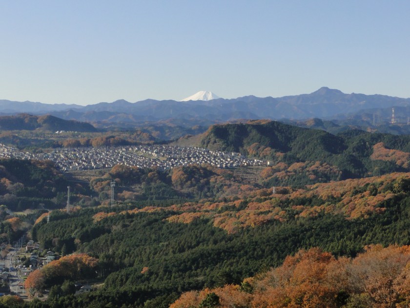
Mt Hiwada 日和田山, Saitama Prefecture
Mt Hiwada 305m can be reached on foot from Koma station 高麗 on the Seibu Ikebukuro line (a couple of stops afte Hanno) and belongs to the Okumusashi area 奥武蔵 which is a kind of prelude to the Chichibu area 秩父. There are several paths going up and down and a small shrine on the top. It’s possible to follow the trail beyond the summit which leads to other minor peaks and a lake. My recommendation is to head to Mt Monomi 物見山 and then back the same way
PROS: Station to station hiking, good views of the Kanto plain and Mt Fuji from the top, length can be adjusted
CONS: Some road walking from the station, hike is on the short side unless one extends to Mt Monomi, Hiwada part can be a little crowded
Yugate ユガテ and Mt Ogami 越上山, Saitama Prefecture
Yugate 290m, less than an hour from higashi agano station 東吾野, consists of 2-3 houses and some fields in the Okumusashi hills. There are a couple of benches and it makes a nice spot to stop for a break. Continuing further along a relatively wide and flat path, one eventually reaches Mt Ogami, 566m high. The return is done by heading down the opposite side to the Kuroyama bus stop 黒山 (to Ogose station 越生).
PROS: Easy path to hike, good picnic spot at Yugate, waterfall near Kuroyama
CONS: Some road walking, few views

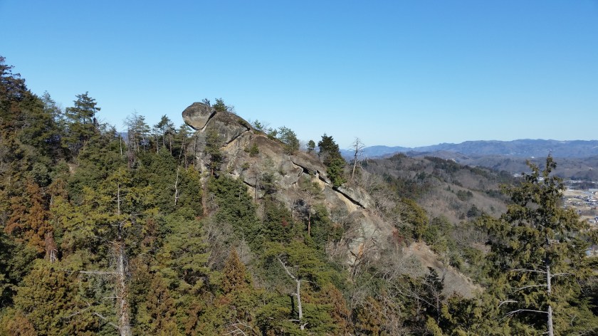
The 5 peaks of Kamanosawa 釜の沢五峰, Saitama Prefecture
This is a hike that I have discovered recently in the low hills that cross the wide valley containing Chichibu city, close to Ogano village 小鹿野. The highest point is 590 meters but lying quite a bit inland, a little snow is always a possibility (it was totally snow-free when I did it it January). There are some steep rocky bits (with chains to assist you) so it isn’t recommended for beginners. The views of the surrounding Chichibu mountains are fantastic and there is an interesting rock formation on the way called kamegadake 亀ヶ岳.
PROS: few people, some “exciting bits”, lots of panoramic views
CONS: bus required both ways, somewhat far from Tokyo, caution required along various steep drops along the way
The Nagatoro Alps 長瀞アルプス, Saitama Prefecture
Another “Alps”, this time West of Nagatoro station 長瀞 on the Chichibu line, the highest point being Mt Hodo 357m. There is a ropeway, a small zoo and flower gardens (including cherry blossoms). The start point is actually the next stop, Nogami station 野上 but one can also start the hike further North as the there is a path that follows the ridge as it curves to the east following the railway line all the way to Mt Kanetsukido 鐘撞堂山 (incidentally a Kanto hundred famous mountain).
PROS: Station to station hiking, good views of Chichibu, hike can be lengthened or shortened
CONS: Crowds since the top is accessible via cable car, somewhat far from Tokyo, lots of the steps near the top of Mt Hodo


One thought on “Where to hike in the winter? Part II Tokyo & Saitama Prefectures”