

Hiking in the Minobu Mountains 身延山地
This is another mountain that was on my must-climb list for ages, in an area relatively close to Tokyo that I had never been to before, between Mt Fuji and the Southern Alps. There is also a ropeway to the summit – I didn’t use it, but it’s nice to have the option. Finally, the temple area at the base of the mountain is the last resting place of the founder of Nichiren Buddhism – less interesting to me, but worth noting.


Above: Summit framed between cedar trees and temple buildings
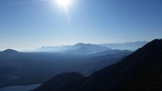
Below: Significantly less snow on the Western side of Mt Fuji
I rode the Chuo line to Kofu, then changed to the Fujikawa Limited Express to Minobu station, arriving just past 9h30. I hopped onto the bus for the short ride to Minobusan at the base of the mountain. A short walk up the main street brought me to San-Mon 三門, one of the three famous gates of Kanto, according to the information board. It was certainly one of the most impressive gates I’d ever seen. Beyond, was also one of the longest stone staircases I’d ever climbed – a good warm-up for the hike ahead. At the top, I took time to check out the temple area before heading up the narrow paved road to the right of the ropeway, a little after 11am.


(Top Left) San-Mon Gate (Top Right) Kuonji Temple (Bottom Left) Bell Tower (Bottom Right) Random temple building inside the forest
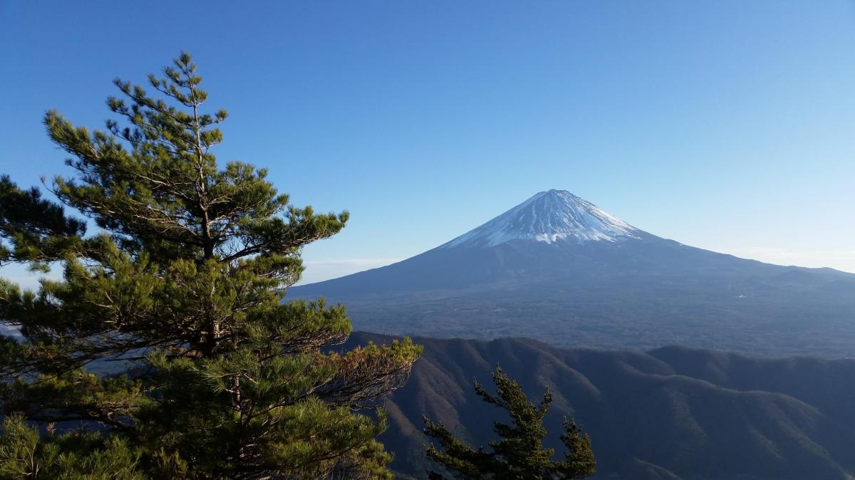
I followed the paved road as it zigzagged up through the forest. There were few views through the cedar trees, almost no signs for the hiking trail, and no people. Occasionally, I could hear buddhist chants drifting up from below. Half an hour later, I emerged onto a shoulder, clear of trees – there was a small temple complex and a view of the summit. The paved road continued into the cool shade of the forest; its condition started to deteriorate, before completely giving up turning into a dirt road. Here, I passed a few hikers (and a dog), but it seemed that the majority of visitors preferred the ropeway. Just before 1pm, I had my first glimpses of Mt Fuji through the trees. A few minutes later, I reached the top of the ropeway, and a fantastic view of Mt Fuji and the Fuji river valley heading Southwards.


(Above) Summit of Mt Fuji behind the Tenshi Mountains (Below) Fuji River flowing into Shizuoka Prefecture
After snapping some pictures, I walked past the summit temple to the other side, where there was the summit marker for Mt Minobu 身延山. I was able to enjoy a great close-up view of the Southern Alps, with the Arakawa-zansan on the left, and the Shirane-zansan on the right, with fresh layers of snow each. Further right was Yatsugatake, in the clouds, and the Oku-Chichibu Mountains, free of clouds. I also had a good view of Mt Shichimen and Mt Fujimi, two mountains I hope to climb next year. Just past the latter was Mt Kushigata which I climbed in June this year.


(Above) Mt Shichimen (Below) Mt Fujimi, two other peaks of the Minobu Mountains
After a short standing lunch – there were no benches – I started walking down. I was supposed to head down the other side of the ridge I had come up, but instead, I seemed to be going down the backside of the mountain. I was the only person hiking down, so there was no one to ask. After triple-checking my map, I decided I was on the right path after all. I was on a paved road again, but I didn’t mind since there were now some good views through a mix of trees. Facing the massive peaks of the South Alps, I felt like I was in the middle of nowhere.
Soon I arrived at a temple manned by a solitary monk. There was an information board with a good map which I studied for a while. The monk hovered nearby. It seemed like he was eager for some conversation but didn’t dare, or wasn’t allowed to initiate it. I noticed Minobu Hot Spring written in English on the map so I asked: “are there any hot springs for day-trippers in Minobu?” “I don’t think so,” he replied. “Do you have to stay here all day?” I asked. “I Yes, but I go back down at nightfall.” He then pointed out the tip of Mt Fuji, above the ridgeline of the mountain behind me. Having run out of questions, I thanked him, snapped a few pictures, and continued along my way.


Beautiful autumn colours in the afternoon light on the way down
The path had now turned nearly 180 degrees, and was finally heading the correct way. I soon reached a magical spot, called “senbon-sugi” 千本杉, meaning one thousand cedar trees (in reality just 260 according to the sign). I’ve seen many cedar trees in Japan – I’ve even seen the Yakusugi on Yakushima – but I thought these were really impressive. They went straight up to amazing heights – I estimated over 40 meters, but according to the signboard, some of them topped 60 meters. I spent some time gazing and photographing these awesome trees.


The Japanese Cedar (scientific name: Cryptomeria), also known as the Japanese Redwood, is related to the American Redwood or Sequoia
I finally managed to pull myself away, and continued to head down along the road, still paved. It was now 3pm and I had to speed up if I wanted to get down before dark. There were some good views of Mt Shichimen to the right, with the sun slowly dipping below the ridgeline. I soon reached a viewpoint of the valley below and the turnoff for a hiking trail – finally! The path took me straight down the side of the mountain, cutting across the forest road several times. At one point, I had an excellent view of Minobusan town, and the temple complex perched above. I could again hear the buddhist chants drifting up below, creating a special atmosphere unique to Japan. I hurried on, finally reaching the base of the mountain and Minobu town around 4pm, in the time to catch the bus back to the station. As I was told by the lone monk on the mountain, there were no hot springs for day-trippers anywhere in Minobu. However the town does have a very beautiful five o’clock chime (see Video below) which played while I was waiting for my train back to Tokyo.

Minobusan town and the temple where I started my hike five hours earlier
See the views and listen to the sounds of Minobu

NEXT UP: Mt Sanpobun (Fuji Five Lakes) in Yamanashi


You must be logged in to post a comment.