
UPDATE MAY 2025
The Inamuraiwa Ridge Route (稲村岩尾根), described in this blog post, is currently closed as several trail sections have collapsed due to a typhoon. It is recommended to use one of the routes on the south side for climbing this mountain.
This isn’t a very famous mountain, but many people climb it since it’s one of the ways up Mt Kumotori, a hyakumeizan, as well as the highest summit in the Tokyo prefecture. It’s also inside the Chichibu-Tama-Kai National Park. I left Tokyo (the city) under the sun, but arrived under clouds and drizzle – how the weather can change fast!
HOW TO GET THERE: The best way is to hop on the early morning direct train to Okutama from Shinjuku station, otherwise you will need to change trains at least twice. If possible, sit in the front carriage, since this will put you close to the station exit; then make sure be at the front of the line for the bus, since this will guarantee you a seat. The bus for Nippara, also the stop for this hike, departs right in front of the train station.
THE ROUTE: After getting off the bus, I quickly continued walking along the road through the village. I knew the way since I had been here earlier this year to visit the Nippara caves. Also I was on a tight schedule and I didn’t have time to dawdle. Since the mountains were shrouded in mist, for once I didn’t lose any time taking photos. I arrived at a sign pointing to a footpath going down to the left, leading into the forest, over the river at the bottom of the valley and up the other side. It was pretty, but also slightly spooky, since there was no one else.
The path led me to a river bed through a ravine – it was remarkably beautiful (but difficult to take in photo). The approaching sound of bells told me that some other hikers were right behind me, but I lost them quickly on a steep slope. It took me away from the riverbed, and to the start of a rocky outcrop jutting above the ravine I had just climbed. Another group of hikers returning from the top of this outcrop told me it took 15 minutes to reach.
Despite my tight schedule I decided to attempt it since I was making good time. The rocky outcrop was somewhat slippery because of the recent rain, and turned into a bit of a scramble at the end. However it was worth it – even though the surrounding peaks were hidden in the clouds, I could see down the valley and the Nippara village below. Trees were showing their autumn colours here and there. It was hard to believe I was still in Tokyo prefecture.
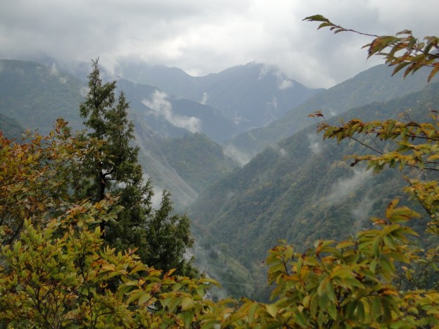
View from the rocky outcrop – yes this is Tokyo prefecture.
Fifteen minutes later I was back on the main trail, and set off at a fast pace to make up for the lost time. Soon I was surrounded by mist. This made the climb doubly hard because it was impossible to see the summit – every time I thought I was about to arrive, the mist gave way to more forest and more climbing. Everything around me was silent and it felt a bit gloomy.
Finally I reached the top of Mt Takanosu (鷹ノ巣山 takanosuyama). There were a lot of people, but still plenty of space to sit down and have lunch. As expected there was no view to reward my efforts – just a lot of uniform whiteness. I headed down at once after lunch. There was really no point in hanging around, and I wanted to get back on schedule so that I would have time to take a hot bath at the end, and catch the direct train back to Shinjuku.
I thought that the way down was much nicer than the way up – a nice wide grassy ridge similar to a fire barrier. The mist went from spooky to mysterious. Suddenly I came to a point where the ridge turned right and went steeply downhill. The hiking trail seemed to be heading the same way. I was afraid of going down the mountain too soon, so I started to consul my map. Another hiker who had also been checking his map at the same place, told me this must be the right way. He was quite convincing so I started to follow him, anxious not to lose any more time. The path levelled and all seemed well; it started climbing again, became faint and then disappeared. We both stopped to look for it through the mist. Eventually I found it twenty meters to our right. We were on a minor summit and the main trail had gone round it. I said goodbye to the other hiker, and continued ahead at at a fast pace. Funny things like this happen all the time.
Soon I came close to another minor summit, Mt Mutsuishi 1478m (六ツ石山 mutsuishiyama). The name means six rock mountain. It was only 5 minutes to the top so I went up. The top was grassy with some trees but looking back I could see Mt Takanosu. Since the elevation of Okutama station is only 350m, I knew I still had a long way down, and I quickly set off again. Soon the weather cleared up a little, allowing some sun through. I slipped on some rocks on a steep slope, somehow spinning around 180 degrees and landing with my chest on a rock. It knocked the wind out of me, but otherwise no damage done. Lower down, I had to navigate a slippery muddy path through thick forest. At one point I slipped again. After that, I decided to leave the path and walk through the forest alongside it. This is one reason not to go hiking after a period of rain.
Eventually I reached gentler slopes, an easier to walk path and finally a paved road. I was probably just above the old Okutama road which I had walked this year in May. At the entrance of the hiking path, there was a sign that a bear had been spotted at this location a few weeks ago. For one’s state of mind, I find it better to know this after the hike, rather than before. After another 30 minutes I was back inside Okutama town. From past experience, I called the hot spring Moegi no yu, but they told me it was very crowded at the moment and I would have to wait to get inside. I decided to skip my hot bath so that I could catch the last direct train for Shinjuku. As a consolation, I treated myself to some local sake on the ride back.
CONCLUSION: A surprisingly good hike with some pleasant ridge walking ending at the station. Definitely worth another shot in better weather. The official name for the hike from the summit down to Okutama is the Ishione Ridge Walk (石尾根縦走路 ishione jusoro).

Beware of bears
![Mt Shakushi (1597m), Fujiyoshida City, Yamanashi Prefecture [MAP AVAILABLE]](https://hikingtokyo.com/wp-content/uploads/2012/11/dsc05095b.jpg?w=1200)




You must be logged in to post a comment.