
I had wanted to visit Shibireko Lake ever since I’d found out about it from the Yuru Camp anime. Looking online, I recently found out that it was possible to hike from the lake to a nearby mountain with a view of Mt Fuji. Along the way, it was also possible to make a short detour to another summit with a view of the Kofu basin. Outside these two viewpoints, the hike was mostly in the trees, perfect for seeing the autumn leaves, hopefully at their peak. The hike, up and down the same way, was on the short side, ideal for the shorter days of Autumn.
Hiking in the Misaka Mountains 御坂山地
To reach the start of the trail, I’d ride the Chuo line Limited Express to Kofu, and then drive the rest of the way, as there is no public transport to the lake. The weather was supposed to be sunny all day with temperatures warm for the season. I was looking forward to seeing Mt Fuji with new snow on its summit and hoped that, although the lake was no longer a secret due to the recent camping boom, the trail would still be relatively unknown.
For subscribers, read this Post on Hiking Around Tokyo for a better viewing experience and the latest updates
Get a Map of the Mt Hiru Hike
This map was developed for Japanwilds with the Hokkaido Cartographer
Find Japan Hiking Maps on Japanwilds

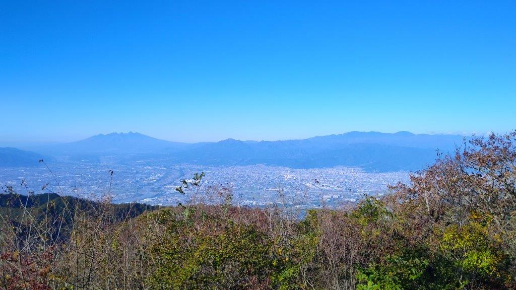
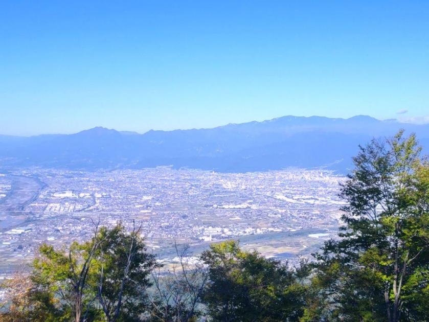
Minami Alps (left), Yatsugatake (back center) & Kofu Basin from Mt Obatake
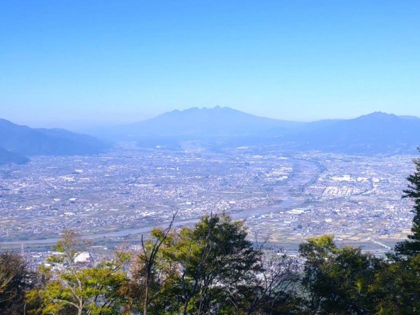
Yatsugatake (left), Oku-Chichibu (right) & Kofu Basin from Obatakeyama
It was a beautiful Autumn day as I rode the limited express, arriving at Kofu station at 1030. By 11am, I was driving south, towards the South Alps, still completely free of snow. Shortly after noon, I pulled into the large parking lot belonging to Sumeiso Lodge, also available to day-trippers for a small fee; I had passed almost no cars during the drive up the two-lane Shibireko-koen line, a good sign for today’s hike. After getting ready, I set off at 1230, walking up the mountain side and away from the lake, hidden from view by the thick forest.

Narrow Section of the Hirugatake Trail

Sun Shining through the Trees Halfway to Hirugatake
It was a steep but short climb to the ridgetop, where I turned left along a level trail. At 1pm, I emerged onto the flat top of Mt Obatake (大畠山 oobatakeyama), with a bench and a view on the west side, as well as a telecommunication tower. I could see the South Alps, Yatsugatake and the Oku-Chichibu mountains; directly below, was the triangular-shaped Kofu Basin (kofu-bonchi), the urban sprawl running right up to the base of the mountains and the blue ribbon of the Kamanashi river splitting it in half. I settled on the summit bench for a thirty-minute lunch break then retraced my steps to the ridgetop intersection.

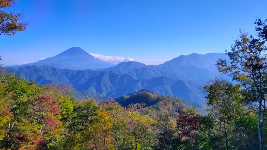
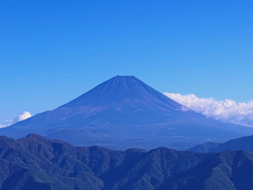
Snowless Fuji from the Summit of Hirugatake

Mt Fuji (left), Mt Ryu (center) & Mt Kenashi (right) from Hirugatake
I was relieved to see that this trail was still a well-kept secret as I saw few hikers along the way. The trail alternated between level and gently climbing sections; a couple of narrow traverses required careful walking. The Autumn leaves were still turning at this elevation but the surrounding forest was beautiful. A little after 2pm, I reached Nishikata Pass (西肩峠) where I turned left for the final climb to the summit. At 2h30, I was standing at the top of Mt Hiru (蛾ヶ岳 ひるがたけ hirugatake meaning Mt Moth), a Yamanashi 100-famous mountain. Although the name sounds the same as the highest peak of the Tanzawa mountains, it’s written with a different Chinese character.

Closeup of Mt Fuji from Hirugatake

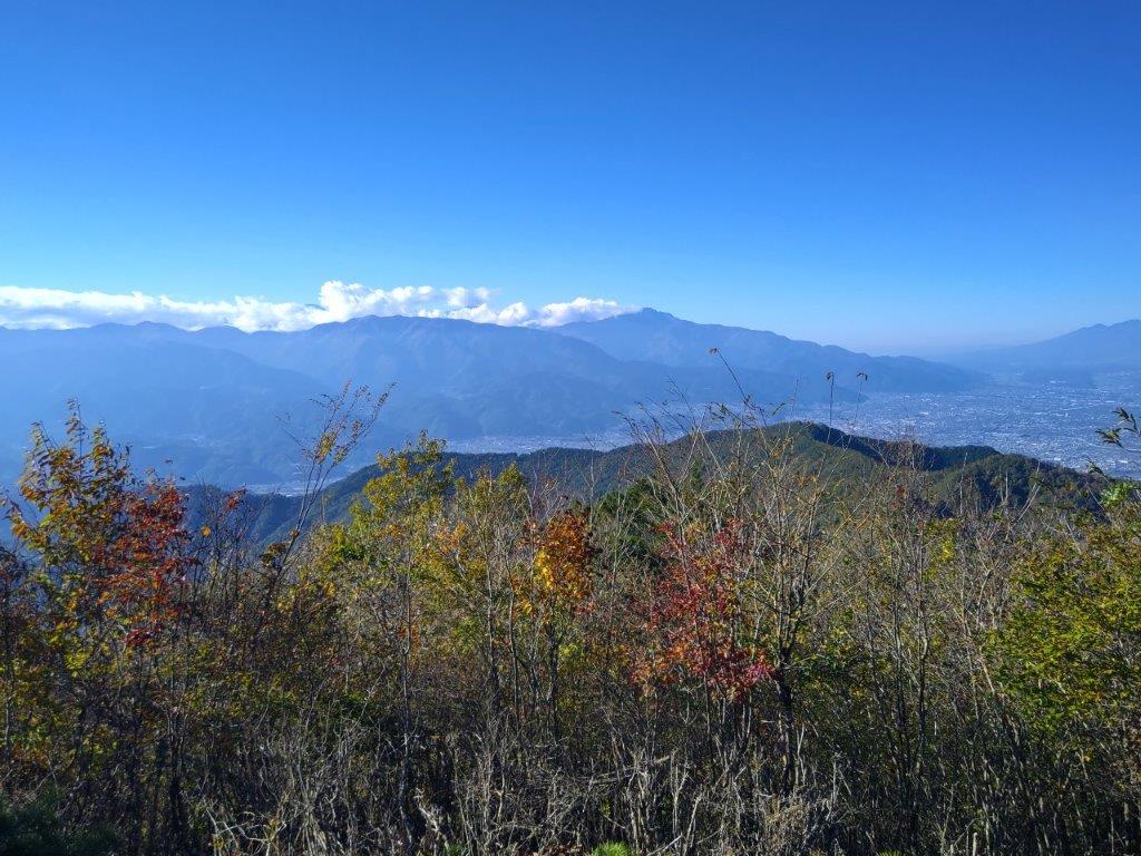
Autumn Colours at their Peak around the Top of Hirugatake
I was stunned to see that Mt Fuji still was completely snowless. However, its perfect cone on a blue sky background was beautiful even without its trademark white cap. To its right, I could see Mt Ryu and the long summit ridge of Mt Kenashi, with splendid autumn colours in the foreground; on the west side, I had a view similar to the one from the previous peak, but from a higher vantage point; I could also see the ridgeline I had walked between today’s two mountains. After a short break on the summit bench, enjoying the gorgeous view all by myself, I headed back down the same way.

Mt Kenashi from Hirugatake
The Minami Alps from Hirugatake
I enjoyed the solitary stroll back through the forest, the scenery looking slightly different in reverse. Through gaps in the trees, I had views of the Misaka mountains on the north side. One hour later, I was back at the nearly empty parking lot. Since I still had half an hour before sunset, I decided to quickly walk around Shibireko Lake (四尾連湖) before heading back.

Walking back to Shibireko Lake

Walking around Shibireko Lake
I was surprised to see that the campsite extended around the entire south half of the lake; some spots almost felt like wild camping. Even at dusk, people were still rowing boats across the lake. Half an hour later, I had completed my tour. After checking out the Yuru Camp related exhibits inside Sumeiso Lodge, I hurried back to my share car for the one hour drive back to Kofu station. There I boarded the limited express for the 90-minute ride back to Tokyo.

Shibireko Sumeiso Lodge

After Sunset at Shibireko Lake
The entire hike, including the lake loop, took about 4 hours. The view from the top of Mt Hiru was much better than I had imagined and deserves a place among the best mountain tops to view Mt Fuji. The hiking trail extends west from Mt Obatake and east from Mt Hiru and I hope to explore them one day in the future. This was my third Yuru Camp inspired hike, the first two being Takapotchi Highland and Hottarakashi Onsen. This was also my first proper sighting of Mt Fuji since Mt Sasagogangaharasuri in January of this year, and hopefully not the last one!
Watch a Video of the Mt Obatake & Mt Hiru Hike
Watch the Video of the Hike on YouTube


See a Slideshow of More Pictures of the Hike
