

Read this Blog Post on Hiking Around Tokyo
I wanted to make another trip to Shiga Highland since I had such a great hike there last year. I had been planning to use the Ryuo ropeway for a while, but needed good weather to justify the expense. I had my chance after a typhoon passed over East Japan, bringing clear blue skies in its wake. My hiking map from ten years ago showed a trail between the ropeway and the Oku-Shiga ski resort; however, it was absent in future versions. Looking at online reports, I saw that a trail still existed and that I could do a roundtrip to the highest point, although it was hard to tell the duration. I would take the shinkansen to Nagano and then the Nagano Dentetsu line to Yudanaka; there, I could catch a free shuttle bus to the base of the ropeway. For the return, I had to make sure to catch the last ropeway at 5pm. It was supposed to be quite hot, but hopefully it wouldn’t affect me much, since the hike would be mostly above 1800 meters. I was looking forward to visiting a new part of Shiga Kogen and getting some great views on a clear day.
Hiking in the Joshin-Estu Kogen National Park
上信越高原国立公園
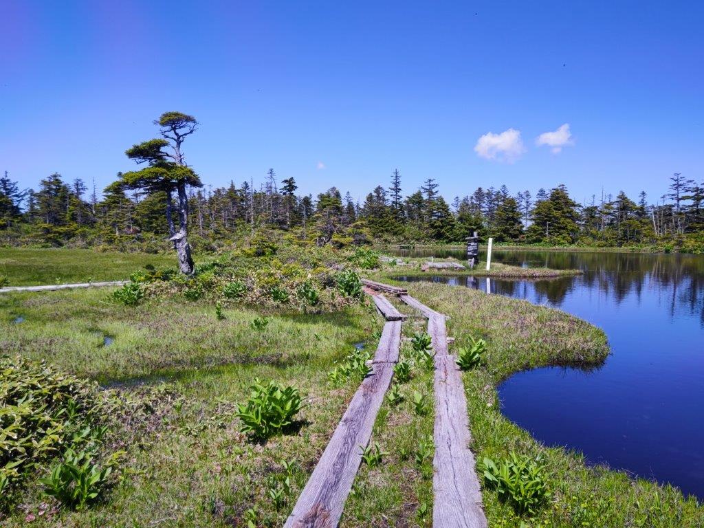
Chigoike Wetland, near the top of Mt Yakebitai
View of Togakushi Kogen from Sora Terrace
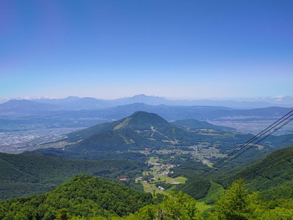
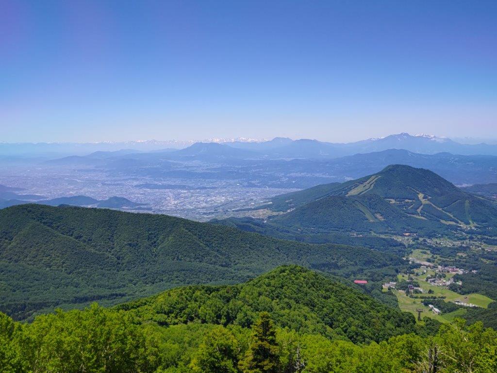
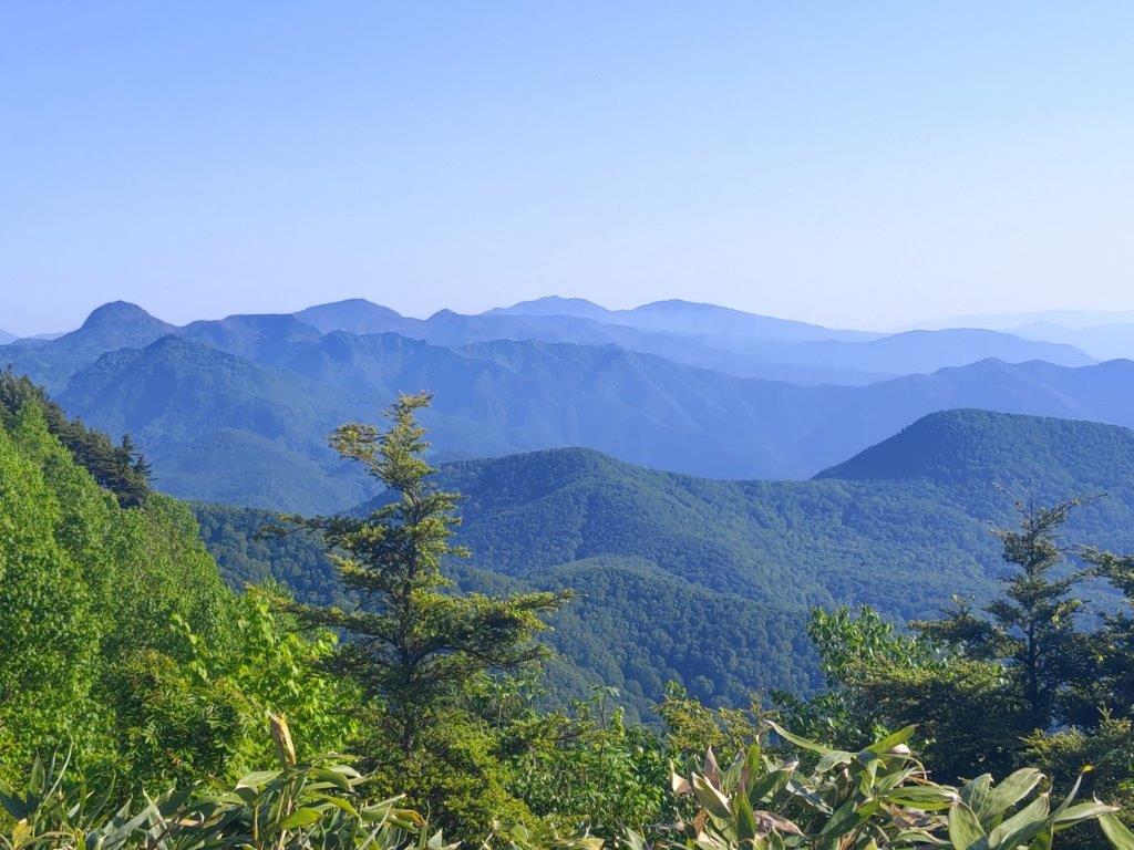
It was the perfect day as I rode the shinkansen to Nagano, where I caught the limited express “Snow Monkey”, arriving at Yudanaka around 1030. I was one of the few people to board the minivan, departing opposite the station, for the half an hour ride to the ropeway, located in the North part of Shiga-Kogen. At 1130, I finally reached Sora Terrace at the top of the ropeway, where I had a sweeping view of the mountains of Nagano, completely free of clouds. In the background, was the entire range of the North Alps, the highest peaks still covered in snow. In the foreground, was Togakushi Highland and its many volcanoes: Mt Takatsuma, Mt Iizuna, Mt Kurohime, Mt Myoko, and its highest peak crowned in white, Mt Hiuchi; closer still was Mt Madarao, climbed in the summer and skied in the winter; directly opposite was Mt Kosha, a summit I hope to climb soon.
View towards Nagano
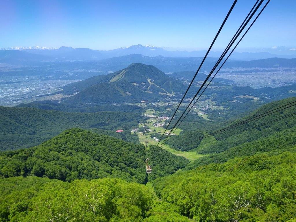
View of the Ryuo Ropeway
I was surprised by how warm it felt, even though I was 1770 meters high. After admiring the view, I set off just before noon. First, I followed a gently climbing ski slope through the forest, wide enough to be out of the shade; I was feeling pretty hot and wondered if I had enough water. I soon reached the start of a short loop through the Ryuo summit wetland (竜王山頂湿原), along a wooden walkway on the left side. It took about ten minutes, but gave me a close look at the natural beauty of the Joshin-Etsu Kogen National Park. I resumed my hike and soon made my way up a steeper slope, eventually reaching a (closed) restaurant at the top of the Ryuo ski resort.

The North Alps still covered in snow
Close to Far: Mt Kosha, Mt Madarao and Mt Myoko
Turning around, I had a view of the North Alps framed by pines, as well as the round top of Mt Yakebitai, to be climbed on the return. I soon located the start of the trail on the right side: although there were no signposts, pink ribbons were attached to trees at regular intervals; thick forest on both sides made the use of a GPS device superfluous. The path descended into a broad valley, completely hidden from the outside world; above the trees, I had my first view of today’s highest peak. Very soon, I was climbing up a steep slope, sweating a lot in the heat; I had to use my head net to keep out the many insects. A little before 1pm, the slope leveled and a wooden walkway suddenly appeared.

A short loop through the Ryuosancho-Shitsugen

Looking back at the summit of Mt Ryuo
I soon arrived at a stunningly beautiful pond, chigoike wetland (稚児池湿原); although it was shown on my map, I hadn’t expected anything like this. I had also arrived at the summit of Mt Yakebitai (焼額山 やけびたいやま yakebitaiyama). After some lunch, I dropped my pack and did tour of the wetland, following the walkway counterclockwise. On the west side, Mt Kurohime and Mt Myoko rose majestically from the edge of the grassy wetland. On the east side, I emerged from the forest onto another ski slope, looking totally different from the time I was there on skis.

The summit of Mt Yakebitai, across the hidden valley
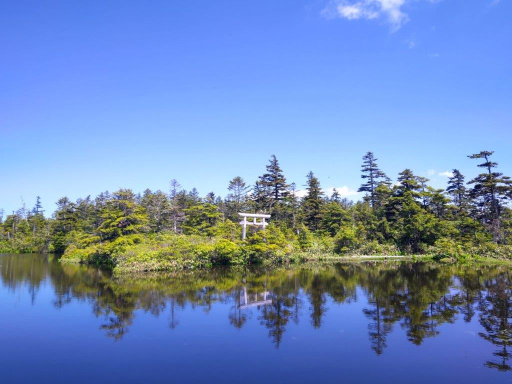
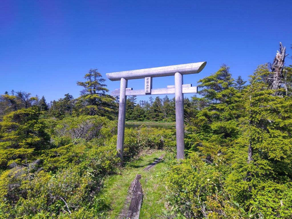
Wooden Shinto Gate at Chigoike Wetland
I had another amazing view, this time of the mountains of Niigata, many of them yet to be climbed. From left to right, I could see Mt Torikabuto, Mt Naeba, Mt Shirasuna and Mt Iwasuge, its side view resembling a ship. It was already 2h30 so I quickly completed the loop, passing near a small shrine and its wooden “torii” (Shinto Gate), looking quite magical among the pines, next to the pond. A little before 3pm, I set off for the return, reaching the top of Mt Ryuo (竜王山 りゅうおうさん ryuuousan) less than an an hour later. Sadly the path to the summit was overgrown by vegetation and view of Shiga Kogen to the south was mostly hidden by trees. I could only stay a few minutes till swarms of insects forced me to retreat.

Mt Kurohime and Mt Myoko rising from the wetland

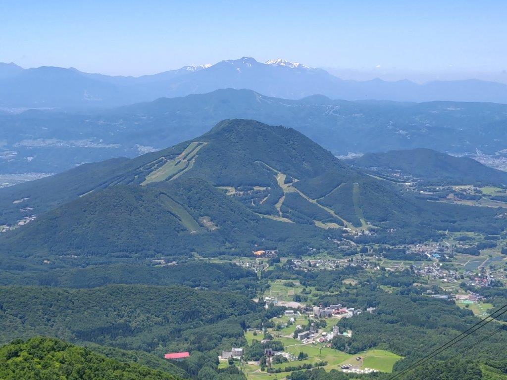
Top of the Oku-Shiga Ski Resort
I was absolutely astounded that the trail I used on the return was not better known. I had frequent views on the left side through breaks in the vegetation. Fortunately I was ahead of schedule, so I could take my time. After the peaks of Shiga Kogen, including Mt Kasa, Mt Kusatsu-Shirane and Mt Azumaya, I also had a magical view of Mt Kosha, Mt Madarao and Mt Myoko, lined up and shrouded in the afternoon haze. I arrived back at the ropeway just before 4h30, relieved that I had made it back with time to spare. Once back at Yudanaka, I regretfully had to skip the hot spring next to the station, as I wanted to catch the last limited express for Nagano, where I then hopped onto the shinkansen for the 90 minute ride back to Tokyo.
View of Shiga-kogen from the path between Mt Ryuo and the ropeway
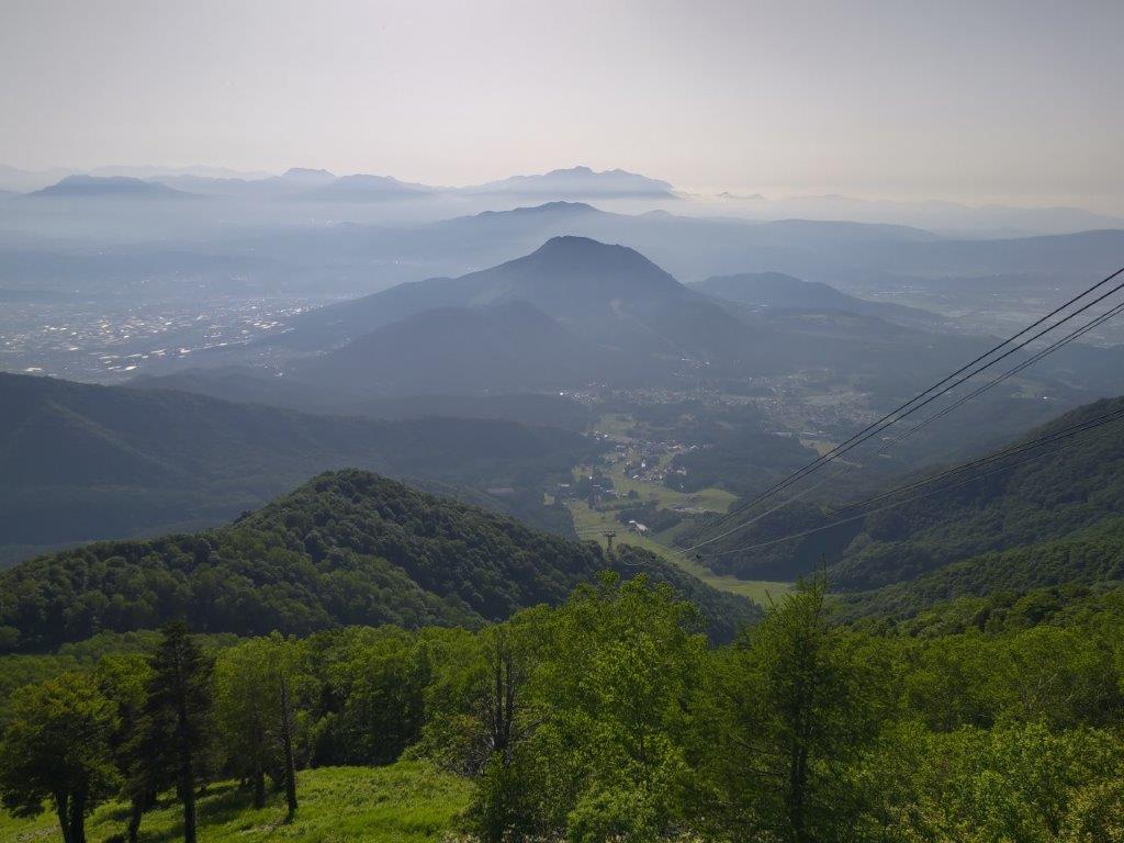
Magical view of Mt Kosha, Mt Madarao and Mt Myoko
I was glad I was able to complete the roundtrip to Mt Yakebitai as a daytrip from Tokyo, in less than 5 hours at a relatively fast pace. I was also pleased to discover the beautiful Chigo Pond; I couldn’t believe I had it totally to myself. It’s a total mystery why the trail has been abandoned and this place isn’t better known. I was also surprised that the ropeway itself didn’t have more people, although the rainy season might have something to do with this. From the pond, I found a signposted trail heading down into Oku-Shiga, so I hope I can return to do it one day.
Watch a Video of the Mt Yakebitai and Mt Ryuou Hike
Watch the Video of the Hike on Youtube


Watch a Slideshow of More Pictures of the Hike

Your blog just popped up as a WordPress-recommended blog for me, and I’m so glad it did! I lived in Okayama prefecture some time ago and miss it in ways that barely make sense given how briefly (about a year and a half) I called Japan “home.” So, this post, though about a trail I never traveled, really brought me back in a delightful, unexpected way. (It being 7 a.m. here, I’m delighted to start my day in a way that includes this post. Thank you.)
Thank you for your nice comment. I’m glad you enjoyed this blog post. Having lived in many countries around the world, I totally understand how you feel. I hope you can return to Japan one day and travel some of the trails in this blog!