It seemed that north-eastern Japan didn’t share the sunny autumn weather of the Kanto area, as most of the central, mountainous part was continuously engulfed in cold, cloudy weather. I was forced to look southeast for a place with more suitable hiking conditions, and I finally settled on this remote mountain, the highest peak of the Abukuma Plateau (阿武隈高地). It was also an opportunity to ride a new train line, the Ban-Etsuto line (磐越東線). There was no public transport, but since the trailhead was only a short taxi ride away, I felt it wouldn’t be an issue. The weather forecast was sunny but with strong winds. Since this was a relatively low mountain below the tree line, it didn’t worry me either. I was really looking forward to seeing the summit view in an area I had never been to before.

View of the Abukuma Plateau halfway up
I had great views of the Nikko mountains on the shinkansen, thanks to the clear weather over the Kanto area. At Koriyama station, I transferred to the local JR Ban-Etsuto line and arrived at the tiny station of Kanmata at 10:40. The taxi driver wasn’t familiar with the start of the hiking trail; at first he thought I wanted to go to Abunuma Cave (something for another visit), so I ended up giving him directions using Google Maps. At 11:20, I was finally ready to start hiking up the “ishipokke” (石ポッケ) trail. Although it’s a 300-famous mountain of Japan, at times the path was hard to follow; I had to hunt for the “pink ribbons”, small strips of coloured paper attached to tree branches marking the way. Soon I was walking through green bamboo grass among white bare trees under blue skies – quite similar to my recent hike on Mt Izumi. There were no other hikers on the mountain; apparently it isn’t a popular hiking destination in the colder months. Some trees were twisted into fantastic shapes reminding me of the Spooky Old Tree children’s book.

Hiking up through the bamboo grass

One of the “fantastic” trees along the way
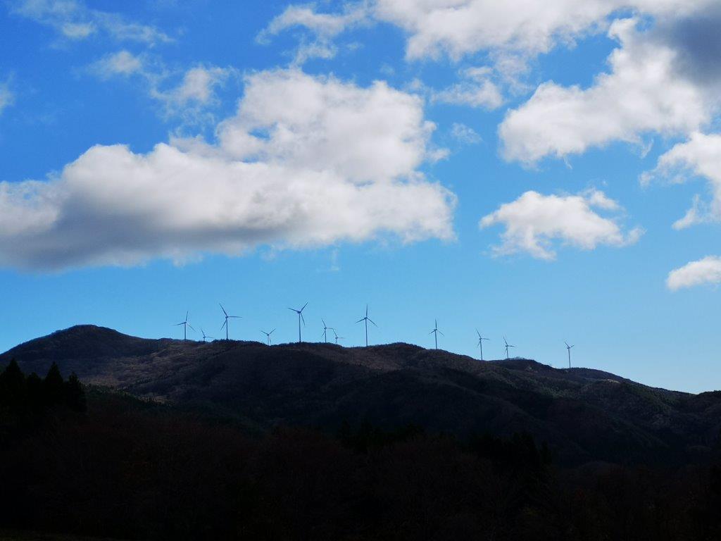
The mountainside soon became dotted with boulders, probably the reason behind the name of the trail (“ishi” means stone in Japanese). They had interesting names like “yareyare ishi” (meaning “oh dear! rock”). Around the same time, the wind suddenly picked up and clouds filled the sky. At 12h30, I reached a series of huge rocks taller than the trees. I climbed on top of the biggest one, and nearly got knocked down by the powerful gusts (see video). I was surprised that the wind could be so strong at this low altitude. Staying on all fours, I quickly snapped some photos of the view. Eastwards was the Pacific ocean; stretching southwards, I could see the low mountains of the Abunuma plateau; westwards, Mt Nasu was sitting under big, dark clouds; finally, looking northwards, I could see the highest point of today’s mountain. It was also the location of a Japan Self-defense base, in the shape of a white sphere, like a planetarium. Directly below in the opposite direction, wind turbines were working hard on this windy day. I was glad to see alternative forms of energy taking root in the area.

View from the “pokke” rocks

The Abunuma Plateau
I managed to eat my sandwich before it got blown away, and left as soon as I was done, since the sun was now in the clouds and it was freezing cold. A little after 1pm, I reached the turn-off for “perapera-ishi“(ペラペラ石) which according to my guidebook was worth a look. It took me 15 minutes of mostly level walking to reach a collection of big rocks looking out on the Pacific coast. Dark grey clouds hovered above, and the view wasn’t as great as I had hoped. In the distance, I thought I could see a chimney of the Fukushima Daiichi nuclear power plant just 30 kilometers away, where disaster had struck about 10 years ago. Back then, some people in Tokyo were afraid of Fukushima, but now some people living in places such as Fukushima are afraid of people from Tokyo. I retraced my steps to the main trail, and continued to the nearby summit area.
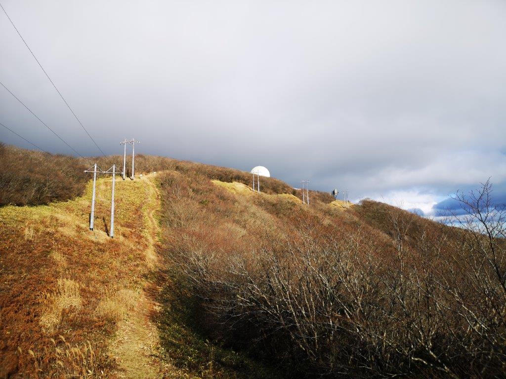
Skirting the south side of the base

The wind turbines were working hard today
The path didn’t lead directly to the highest point, but first skirted the southern side of the base; on the left was a wide view of the valley. I soon reached another intersection, where I took a level path on the right through the forest. At 2h15, I finally reached a shrine that doubled as the summit marker of Mt Otakine (大滝根山 おおたきねやま otakineyama). Right next to it was the base, surrounded by a fence and blocking the view on the north side (the south side was blocked by trees); although the base looked impressive from a distance, I felt envious that only self-defense soldiers could get a view after climbing the mountain (if they didn’t helicopter up). I made my way back to the intersection where the view was better and sat down in the grass to have the rest of my lunch. This time I was able to enjoy it more, as the sun had come back and the wind was busy blowing somewhere else. Seen from above, the impressive “pokke” rock formation reminded me of Mt Komochi.

Following the power line down the mountain
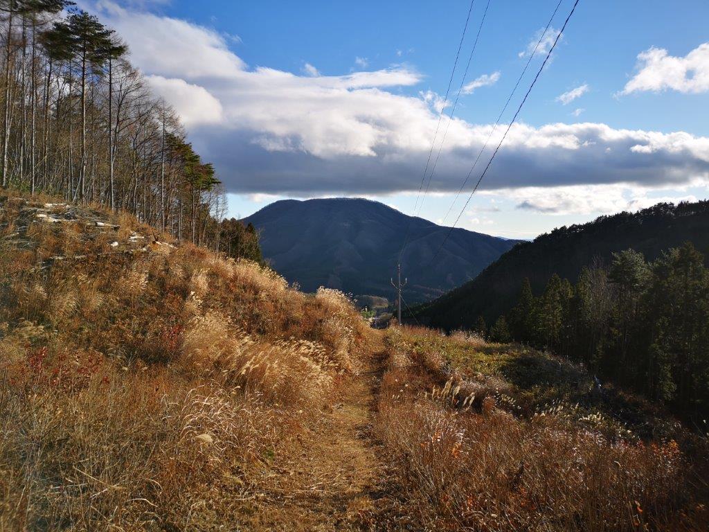
Golden pampas grass in the afternoon sun
I checked my watch and saw that it was past 2h30. I had to get back to the station in less than two hours, including walking back to the station. The return path followed a clearing made for a power line and electric poles, heading straight down the mountain. It was steep and tough on the knees but the bird’s-eye view was worth it. Lower down, as the slope became less steep, I enjoyed walking among the “suzuki” (Japanese pampas grass), golden in the afternoon sun. It took me about 30 minutes to reach the road at the base of the mountain. From there it was another hour walk to the station. Looking back occasionally, I could see the round white self-defense base shining in the late afternoon sun, the grey “pokke” rocks poking through the winter forest, and the silver wind turbines spinning in the never-tiring wind.
See the strong winds that nearly blew me off my feet on Mt Otakine