
Here are two hikes from a couple of years ago in December that had one thing in common: great views of snow-covered volcanoes, on opposite sides of the Kanto plain, separated by 120 kilometers. One was the famous Mt Fuji, and the other one was the lesser-known, but currently active, Mt Asama.
Mt Settou (1736m), Mt Junigadake (1683m) Kawaguchiko Town, Yamanashi Prefecture, Sunday December 3, 2017

I had already hiked parts of the Misaka mountains – the mountainous area between Mt Fuji and the Oku-Chichibu mountains (for example Mt Ou to Mt Oni). However, I had never hiked the central part, between Kawaguchi and Saiko lakes. I decided to approach from Ashigawa valley on the North side, and finish at lake Saiko, on the South side. I took the Chuo line to Isawa Onsen station, and then the bus to the farmer’s market in Ashigawa 芦川. I had a very good impression of the place since they offered me free tea while I got ready for my hike!
The Fujikyu bus from Isawa Onsen to Ogossoya (the Ashigawa farmer’s market) was discontinued in 2024. Access is now via car, or by bus from Kawaguchiko Station. However, since 2024, a free shuttle bus runs on weekends between Ogossoya and Suzuran.

Kawaguchiko City surrounded by nature
I started out after 10am, and walked along the road for about 20 minutes to the start of the trail, which then went straight up the side of the mountain, through trees completely bare of leaves. I reached Oishi pass (1515m) 大石峠 around noon. I had been there once before when hiking from Mt Kuro further to the East. This time I turned right and continued Westwards along the ridge.

Kofu valley and beyond the Oku-chichibu mountains
The hiking path went up and down a wide ridge through beautiful evergreen forest. I had occasional views of Mt Fuji to my left, lake Kawaguchi behind me, and the Ashigawa valley to my right. I soon reached the top of Mt Settou 節刀ヶ岳 the third highest mountain along the ridge, after Mt Mitsumine and Mt Oni. From there I could see all the way to the Southern Alps, and the Kofu valley.
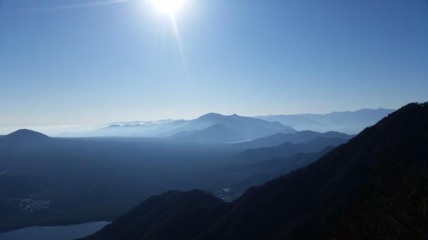
Against the sun, looking back towards Minobu
After admiring the view, I started to head down towards Saiko lake. Soon, I had to negotiate a slightly tricky bit involving some rocks and chains. After that, I arrived at the top of Mt Junigadake 十二ヶ岳 which translates simply as “Peak 12”, from where I had some more great views of Mt Fuji ahead of me. I now had two options. The path to the left was an exciting ridge including suspended bridges. Alternatively, I could head straight down to Izumi no Yu, a hot spring on the side of Saiko Lake. Since it was already 3pm, I decided to head down, and leave the exciting ridge for another hike.

Mt Asamakakushi (1757m), Takasaki City, Gunma Prefecture, Saturday December 9, 2017

For this hike, I drove a rental car from Takasaki city to a small parking area near the entrance of the trail to the mountain. Starting from an elevation of 1450m at 11am, the hike to the top took only one hour. Although the top of Mt Asamakakushi 浅間隠し, meaning “Hidden Asama” was similar to that of my previous hike, it was a lot colder, since I was further North.

Yatsugatake in the background
The view of snow covered Asamayama to the West was breathtaking. I could also see the entire Joshin-Estsu mountains forming the Northern edge of the Kanto plain; there are just too many mountains to list here. Southwards, I could make out the Yatsugatake range, Karuizawa and the Oku-Chichibu mountains. Finally the three holy mountains of Gunma – Myohgi, Haruna and Akagi – were all visible in the same panorama.
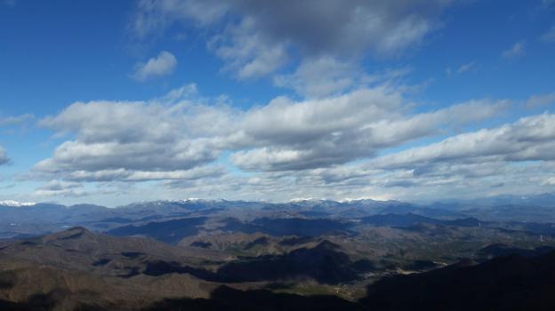
The Joshin-Estsu mountains
After an hour taking pictures and eating lunch in near freezing temperatures, I made my way down the same way I had come up. Once back to the car, I drove to the onsen at Hamayu Sanso at the base of the mountain. I got there just before 2pm and I was able to warm myself up, before driving back to Takasaki station.

