I first spotted these two mountains while hiking Mt Hanamagari in January 2016. Before I could attempt them, there were a couple of things I needed to figure out. First, the trail between the two peaks was a dotted line on my map. After checking online reports by other hikers, apart from being super steep, it didn’t seem to be dangerous. Next, as usual, access was a real headache. My guidebook recommended going by car and hiking up and down from Hamayu Sanso (I had stopped there for a bath once after climbing Mt Asamakakushi). However, I felt it would be more exciting to do a traverse instead. I would take a taxi from Yokokawa station to the parking area for Kirizumi onsen and finish at Hamayu Sanso on the other side. The main drawback was that there were no buses back to Takasaki on the weekend (only on weekdays, strangely enough). I resolved to skip the hot bath, and walk ten kilometers from the end of the hiking path to the closest bus stop, a place called Gonda. I just hoped that I would make it in time for the last bus of the day at 4pm, or I would be stuck there. The weather forecast was good, and the autumn leaves would still be at their peak up in the mountains.
Hiking in the Joshin-Etsu-Kogen National Park 上信越高原国立公園

In the middle, Mt Tsunoochi, and on the right, Kennomine (photo: January 2016)
After getting off at Yokokawa station for the second time this month, I was alarmed to see no taxi waiting outside (I hadn’t reserved one). I called the taxi company, and they said they would send a car over at once. Along the way, the driver pointed out the Shinkansen tracks, exiting the side of the mountain before quickly reentering it on the other side. I had hoped to see one zip by above us, but no luck. The taxi dropped me off at the parking below Kirizumi Onsen (霧積温泉). At 10am I was ready to start hiking. First I followed the path leading to the hot spring hotel. Twenty minutes later, after merging with a forest road, I turned right onto the hiking trail.

The trail hugged the south side of the ridge
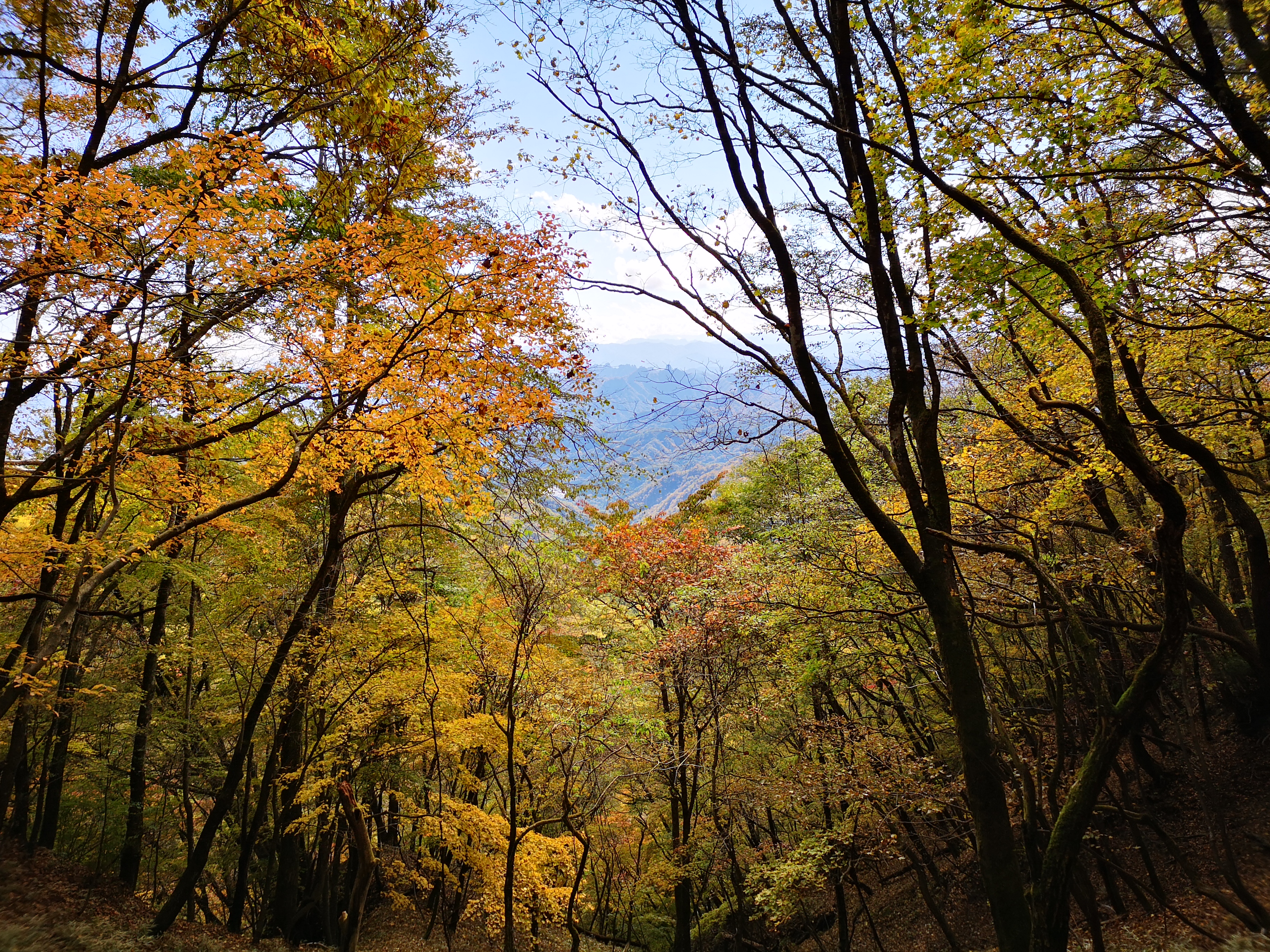
The trail rose gradually through the autumn forest and soon reached a fork. The main trail for Mt Hanamagari went left, but today’s mountain was along the right branch. The trail crossed a flat area and became faint; I had to find my way following the pink ribbons attached to the tree branches. I soon reached the main ridge separating Annaka and Takasaki cities. The next section turned quite adventurous. The path followed the top of the ridge for a short while, then, as the ridge narrowed, dropped slightly, and cut across the south side, staying just inside the Joshin-Etsu-Kogen National Park. There were some ravines to the right; at one point, the path hugged the base of a cliff, and I used the chains attached to the rocky face to keep my balance. Views were sparse, but the autumn leaves were stunning. There was no other hikers and I enjoyed the silence of the forest.

Mt Asamakakushi from Kennomine
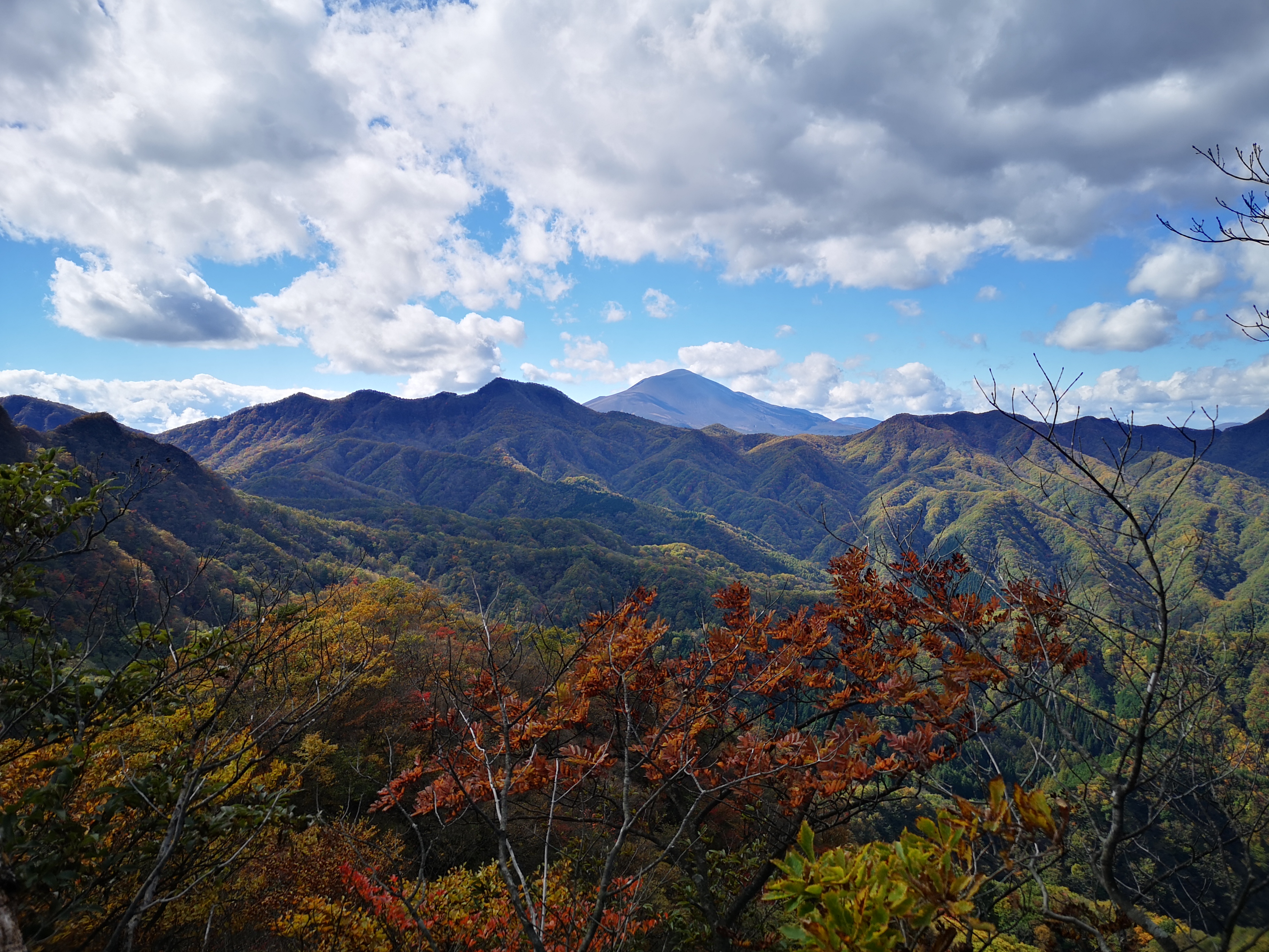
The ridge widened and welcomed the path back. I made my way up a short slope and at 11h30, I had my first views of the day. Opposite was Mt Asamakakushi, and to the left was Mt Hanamagari, with Mt Asama looming behind. In the background, I could make out the peaks of the Joshin-Etsu, still free of snow. There were more clouds on this side and the mountains played hide and seek in the shadows making it difficult to get good photos. I walked a couple of minutes along the ridge, and reached what I judged to be the summit of Ken-no-Mine (剣の峰 けんのみね kennomine) – the summit marker was broken in half, and the mountain name was illegible. I decided to continue without a break. The next section was the dotted section on the map, and I was keen to get it behind me.

The autumn leaves were at their peak
At first, this steep slope didn’t seem like a big deal. I rushed down, occasionally grabbing tree branches to keep my balance. Soon the terrain became so steep that the trail simply vanished. Once again I had to rely on the pink ribbons. They were spaced far apart, and the path didn’t simply go straight down: it twisted and turned, around boulders, over bundles of tree roots, down narrow gullies, and roped sections followed roped sections. I had to stop several times and carefully scan the the whole mountain side to pick up the trail. The last thing I wanted to do was head down the wrong way and have to climb back up. Although the path was dotted on the map, I was surprised that anyone would dare turn this into a hiking path. My guide book suggested going up and down this trail, and I was thankful for having chosen the traverse instead.
Mt Hanamagari, left, with Mt Asama behind and on the right
At noon, it was with relief that I reached the pass between the two mountains. I was now back on a proper hiking path. I would do a roundtrip to the next peak, before heading down the mountain. It took me about twenty minutes of steady climbing, through a festival of autumn colours, to reach the top of Mt Tsunoochi (角落山 つのおちやま tsunoochi-yama), a name that could be roughly translated as “dropped antlers mountain” – I didn’t see any. The summit area was narrow, covered in trees and bushes, and included a small shrine and shinto gate. If I stood near the highest point, I could get a good view of the whole of northern Gunma, all the way to Mt Tanigawa and Mt Hotaka. The view to the south wasn’t as good, but I could still make out the Kanto plain through the trees.

The mountains of Northern Gunma
One glance at the time told me that I would have to keep my lunch break short. I had a little over 3 hours to get off the mountain, and walk ten kilometers to the bus stop. After taking all the necessary photos, I retraced my steps to the pass. There, the trail doubled back along the steep side of Ken-no-Mine. I saw some impressive cliffs, and had to tackle a couple more chain-lined sections. Soon I was walking down a broad river valley through beautiful forest. Even though I was no longer inside a National Park, I felt this part could have been included. Suddenly, I was off the trail. I walked back for a few minutes, and thanks to the pink ribbons, found the path again, along a dried-up rocky river bed. Thirty minutes after leaving the summit, I reached the end of the hiking trail.

Hiking down in the late afternoon
From there, I walked down a forest road for another half an hour before I reached a prefectural road. It was an enjoyable walk that I did at a fast pace, crossing a beautiful mountain stream several times. One of the reasons I opted to walk to the bus stop was that according to my hiking map, there were good views along the road. I wasn’t disappointed. It also said there were monkeys in the area, but I didn’t get to see any this time – perhaps a good thing since I didn’t have much time to spare. After about an hour an a half of fast walking I reached the bus stop a few minutes before the bus was due. I had to change buses once on the way to get to Takasaki, with a one hour wait in-between. Luckily, the bus arrived early, and I was able to catch the previous bus, meaning I got back to Tokyo earlier than expected – always welcome after a long hike!

Mountain view from the prefectural road